IMAGES TAKEN NEAR TO
Balbeggie, PERTH, PH2 6JD
Introduction
This page details the photographs taken nearby to PH2 6JD by members of the Geograph project.
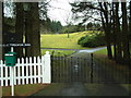
The Geograph project started in 2005 with the aim of publishing, organising and preserving representative images for every square kilometre of Great Britain, Ireland and the Isle of Man.

There are currently over 7.5m images from over14,400 individuals and you can help contribute to the project by visiting https://www.geograph.org.uk
Image Map (Loading...)


Getting Data...Please wait
Leaflet Map data © OpenStreetMap
Images are licensed for reuse under creativecommons.org/licenses/by-sa/2.0
Notes
- Clicking on the map will re-center to the selected point.
- The higher the marker number, the further away the image location is from the centre of the postcode.
Image Listing (28 Images Found)
Images are licensed for reuse under creativecommons.org/licenses/by-sa/2.0
Image
Details
Distance
1
Hoolmyre, near Collace
House on the northern flanks of Dunsinane Hill.
Image: © Mike Pennington
Taken: 11 Oct 2008
0.01 miles
2
Hoolmyre
In 1970, a Socketed Axehead dating all the way back to the Bronze Age was discovered in the Whistle Naked Field below the farm. What kind of stories that ancient tool could tell?
Source: ‘Hoolmyre | Canmore’. 2023. Canmore.org.uk [accessed 12 March 2023]
Image: © Mick Garratt
Taken: 8 Mar 2023
0.01 miles
4
Tullach Ard
Entrance to Tullach Ard, a wooded country estate specialising in Highland cattle. The name is from the war cry of Clan McKenzie, meaning 'The High Hill'.
Image: © James Allan
Taken: 7 Feb 2006
0.05 miles
5
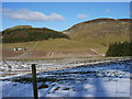
Dunsinane Hill
Looking N from position
Image: © Iain Macaulay
Taken: 6 Mar 2006
0.05 miles
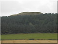
6
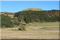
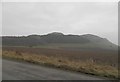
Dunsinane Hill
A fortified knoll which has survived literary fame and a fair bit of quarrying.
Image: © Richard Webb
Taken: 8 Feb 2015
0.12 miles
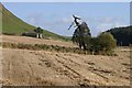
7
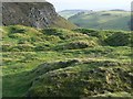
Remains of archaeology.
In Shakespeare’s great tragedy Macbeth “high Dunsinane hill” is Macbeth’s castle or stronghold. But in fact there are at least two separate forts at Dunsinane: a massively defended citadel on the summit of the hill and a larger fort, enclosing the lower terraces of the hill. The larger fort is probably an Iron Age (1000BC-500AD) construction with a settlement of round houses. The inner fort was constructed later, probably on the site of the earlier fortification. Nobody knows for certain whether Dunsinane hill fort actually was Macbeth’s castle, but occupation of the hill-fort probably continued into the early medieval period.
Antiquarians carried out major excavations within the citadel during 1799 and 1854. These unscientific ‘digs’ produced conflicting and confusing records, and greatly disturbed the site. The result of their endeavours is this scatter of undulating mounds, where once the concentric rings of the ancient fortification had been.
Image: © James Allan
Taken: 27 Nov 2006
0.13 miles
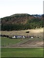
9
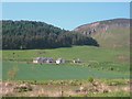
Farm on the foot of Duninsane Hill with the rocky crags of Black Hill beyond
Site of an ancient fort.
Image: © James Denham
Taken: 4 Jun 2010
0.16 miles