IMAGES TAKEN NEAR TO
Sluggan Drive, AVIEMORE, PH22 1UP
Introduction
This page details the photographs taken nearby to Sluggan Drive, PH22 1UP by members of the Geograph project.
The Geograph project started in 2005 with the aim of publishing, organising and preserving representative images for every square kilometre of Great Britain, Ireland and the Isle of Man.

There are currently over 7.5m images from over14,400 individuals and you can help contribute to the project by visiting https://www.geograph.org.uk
Image Map
Images are licensed for reuse under creativecommons.org/licenses/by-sa/2.0
Notes
- Clicking on the map will re-center to the selected point.
- The higher the marker number, the further away the image location is from the centre of the postcode.
Image Listing (24 Images Found)
Images are licensed for reuse under creativecommons.org/licenses/by-sa/2.0
Image
Details
Distance
1
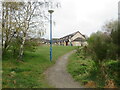
Path into housing estate, Aviemore
A path into a housing estate in Aviemore, in the Highlands of Scotland. Aviemore lies within the Cairngorms National Park.
Image: © Malc McDonald
Taken: 23 Apr 2023
0.04 miles
2
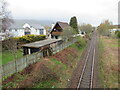
Highland Main Line leaving Aviemore
The Highland Main Line heading north through the outskirts of Aviemore, towards Inverness. This area lies within the Cairngorms National Park.
Image: © Malc McDonald
Taken: 23 Apr 2023
0.04 miles
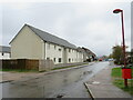
3
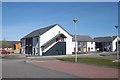
New houses, Sluggain Drive
Aviemore keeps expanding.
Image: © Richard Webb
Taken: 2 Apr 2017
0.05 miles
5
Braeriach Court, Aviemore
Braeriach Court is a minor road through a housing estate in Aviemore, in the Highlands of Scotland. Aviemore lies within the Cairngorms National Park.
Image: © Malc McDonald
Taken: 23 Apr 2023
0.08 miles
6
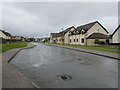
Braeriach Court, Aviemore
Braeriach Court is a minor road through a housing development in Aviemore, in the Scottish Highlands. Aviemore lies within the Cairngorms National Park.
Image: © Malc McDonald
Taken: 23 Apr 2023
0.08 miles
7
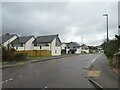
Cairnview Road, Aviemore
Recently-built houses on Cairnview Road in Aviemore, in the Highlands of Scotland. Aviemore lies within the Cairngorms National Park.
Image: © Malc McDonald
Taken: 23 Apr 2023
0.10 miles
8
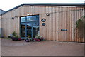
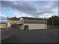
Cairngorm Brewery
On the Dalfaber Industrial Estate.
Image: © jeff collins
Taken: 8 Oct 2013
0.10 miles
9
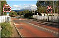
Crossing The Strathspey Railway Line
This level crossing at Dalfaber, on the edge of Aviemore, serves the Strathspey line. The Scotrail line is crossed, in the same square, by a bridge.
Image: © Mary and Angus Hogg
Taken: 20 Aug 2011
0.12 miles
10
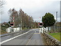
Level crossing on Dalfaber Drive, Aviemore
A railway level crossing with automatic half barriers on Dalfaber Drive in Aviemore, in the Scottish Highlands. The railway which passes through this crossing is the Strathspey Railway, a preserved railway operating over part of a line which British Railways had closed in 1965 as part of the "Beeching Cuts".
Aviemore lies within the Cairngorms National Park.
Image: © Malc McDonald
Taken: 23 Apr 2023
0.12 miles