IMAGES TAKEN NEAR TO
Craiggowrie Place, AVIEMORE, PH22 1UA
Introduction
This page details the photographs taken nearby to Craiggowrie Place, PH22 1UA by members of the Geograph project.
The Geograph project started in 2005 with the aim of publishing, organising and preserving representative images for every square kilometre of Great Britain, Ireland and the Isle of Man.

There are currently over 7.5m images from over14,400 individuals and you can help contribute to the project by visiting https://www.geograph.org.uk
Image Map
Images are licensed for reuse under creativecommons.org/licenses/by-sa/2.0
Notes
- Clicking on the map will re-center to the selected point.
- The higher the marker number, the further away the image location is from the centre of the postcode.
Image Listing (25 Images Found)
Images are licensed for reuse under creativecommons.org/licenses/by-sa/2.0
Image
Details
Distance
1
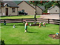
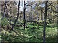
Garden, Dalfaber Estate
This garden seemed not to be attached to any particular house so I assume it must be a community garden.
Image: © Mick Garratt
Taken: 27 Aug 2006
0.06 miles
2
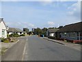
Spey Avenue
Low density housing on the north end of Aviemore. Hopefully after being damaged by urban sprawl and golf, the kame and kettle country around Loch Vaa will remain intact.
Image: © Richard Webb
Taken: 13 Sep 2014
0.09 miles
3
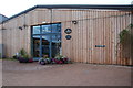
Cairngorm Brewery
On the Dalfaber Industrial Estate.
Image: © jeff collins
Taken: 8 Oct 2013
0.11 miles
4
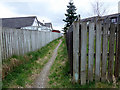
Cycle Route 7
Through a housing estate on the edge of Aviemore.
Image: © John Lucas
Taken: 3 May 2018
0.13 miles
5
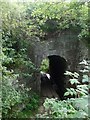
Pedestrian tunnel under Strathspey Railway
This foot tunnel under the Strathspey railway line near Aviemore is also the route of the Speyside Way. As can be seen it also accommodates a small burn which must at times flood the path.
Image: © ronnie leask
Taken: 11 Sep 2009
0.13 miles
6
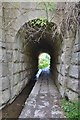
Pedestrian tunnel below the Strathspey Railway line
On the route of the Speyside Way nearing Aviemore; a channel carries the burn draining to the Spey.
Image: © Jim Barton
Taken: 7 Sep 2013
0.14 miles
7
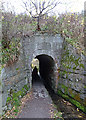
Railway Bridge
This bridge originally carried the Aviemore to Forres line over a burn and a path, but now carries the Strathspey Steam Railway https://www.strathspeyrailway.co.uk/. The path is part of the Speyside Way http://speysideway.co.uk/.
Image: © Anne Burgess
Taken: 24 Oct 2018
0.15 miles
8
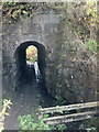
Stream and footpath under the railway
Near Aviemore.
Image: © Andrew Abbott
Taken: 21 Oct 2012
0.15 miles
9
Footbridge over the steam
Near Aviemore
Image: © Andrew Abbott
Taken: 21 Oct 2012
0.15 miles
10
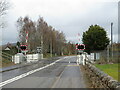
Level crossing on Dalfaber Drive, Aviemore
A railway level crossing with automatic half barriers on Dalfaber Drive in Aviemore, in the Scottish Highlands. The railway which passes through this crossing is the Strathspey Railway, a preserved railway operating over part of a line which British Railways had closed in 1965 as part of the "Beeching Cuts".
Aviemore lies within the Cairngorms National Park.
Image: © Malc McDonald
Taken: 23 Apr 2023
0.16 miles