IMAGES TAKEN NEAR TO
Grampian View, AVIEMORE, PH22 1TF
Introduction
This page details the photographs taken nearby to Grampian View, PH22 1TF by members of the Geograph project.
The Geograph project started in 2005 with the aim of publishing, organising and preserving representative images for every square kilometre of Great Britain, Ireland and the Isle of Man.

There are currently over 7.5m images from over14,400 individuals and you can help contribute to the project by visiting https://www.geograph.org.uk
Image Map
Images are licensed for reuse under creativecommons.org/licenses/by-sa/2.0
Notes
- Clicking on the map will re-center to the selected point.
- The higher the marker number, the further away the image location is from the centre of the postcode.
Image Listing (46 Images Found)
Images are licensed for reuse under creativecommons.org/licenses/by-sa/2.0
Image
Details
Distance
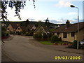
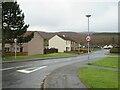
2
The end of Dalfaber Drive
At the junction with Grampian Road.
Image: © Stephen Sweeney
Taken: 5 Feb 2018
0.07 miles
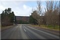
3
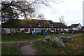
Grampian Road, Aviemore
Grampian Road through the town of Aviemore used to be part of the trunk A9 road. The A9 now by-passes Aviemore, meaning that through traffic no longer needs to pass through the centre of the town. Grampian Road has been reclassified and is now the B9152.
Aviemore lies within the Cairngorms National Park.
Image: © Malc McDonald
Taken: 23 Apr 2023
0.08 miles
4
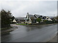
Croftside, Aviemore
Croftside is a resiential cul-de-sac in Aviemore, in the Highlands of Scotland. Aviemore lies within the Cairngorms National Park.
Image: © Malc McDonald
Taken: 23 Apr 2023
0.09 miles
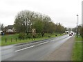
5
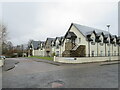
New Houses in Aviemore
Low-rise development on the main road through Aviemore. The Speyside Way follows the path alongside them. The official Speyside Way web site is at http://speysideway.co.uk/ .
Image: © Anne Burgess
Taken: 24 Oct 2018
0.10 miles
6
The Steadings, Aviemore
The Steadings forms part of a modern housing development in Aviemore, in the Highlands of Scotland. Aviemore lies within the Cairngorms National Park.
Image: © Malc McDonald
Taken: 23 Apr 2023
0.11 miles
7
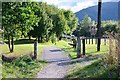
Footpath approaching Aviemore
The Aviemore Orbital Path alongside the B9152 to the north of the town centre. The waymark behind the right-hand post denotes the Speyside Way.
Image: © Jim Barton
Taken: 7 Sep 2013
0.12 miles
9
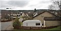
Morlich Court, Aviemore
Morlich Court is a residential road in Aviemore, in the Highlands of Scotland. Aviemore lies within the Cairngorms National Park.
Image: © Malc McDonald
Taken: 23 Apr 2023
0.15 miles
10
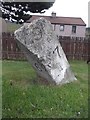
Old Milestone by the B9152, Aviemore, Duthill and Rothiemurchis parish
Granite post by the B9152 (old A9), in parish of Duthill and Rothiemurchis (District), Grampian Road, Aviemore, north end, near Morlich Court, West side of road.
Surveyed
Milestone Society National ID: HI_IVPT31
Image: © Milestone Society
Taken: Unknown
0.16 miles