IMAGES TAKEN NEAR TO
Burnside Place, AVIEMORE, PH22 1SG
Introduction
This page details the photographs taken nearby to Burnside Place, PH22 1SG by members of the Geograph project.
The Geograph project started in 2005 with the aim of publishing, organising and preserving representative images for every square kilometre of Great Britain, Ireland and the Isle of Man.

There are currently over 7.5m images from over14,400 individuals and you can help contribute to the project by visiting https://www.geograph.org.uk
Image Map
Images are licensed for reuse under creativecommons.org/licenses/by-sa/2.0
Notes
- Clicking on the map will re-center to the selected point.
- The higher the marker number, the further away the image location is from the centre of the postcode.
Image Listing (39 Images Found)
Images are licensed for reuse under creativecommons.org/licenses/by-sa/2.0
Image
Details
Distance
1
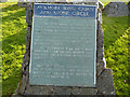
Interpretation plaque at Aviemore Ring Cairn and Stone Circle
Image: © Phil Champion
Taken: 11 Oct 2011
0.06 miles
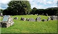
2
Aviemore Ring Cairn and Stone Circle
A Clava-type ring cairn located on the outskirts of Aviemore. Unfortunately the late twentieth century had not been kind to this site, which is now surrounded by a housing estate.
Image: © Phil Champion
Taken: 11 Oct 2011
0.06 miles
3

Aviemore Ring Cairn and Stone Circle
A Clava-type ring cairn located on the outskirts of Aviemore. Unfortunately the late twentieth century had not been kind to this site, which is now surrounded by a housing estate.
Image: © Phil Champion
Taken: 11 Oct 2011
0.06 miles
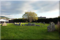
4
Aviemore Ring Cairn & Stone Circle
This ceremonial gathering place is around 4,000 years old. Only the outer ring is visible now, as the central part of the site has been covered up.
Image: © Mary and Angus Hogg
Taken: 21 Aug 2011
0.06 miles
5
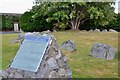
Stone circle, Aviemore
An unexpected structure in the built-up area of Aviemore, just behind the fire station. The structure is probably 4000 years old and a closer view of the information plaque is shown in Image
Image: © Jim Barton
Taken: 7 Sep 2013
0.06 miles
6
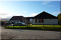
Aviemore Health Centre
Opposite the fire station, at the north end of the village.
Image: © Phil Champion
Taken: 11 Oct 2011
0.07 miles
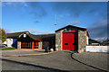
8
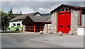
Aviemore Fire Station
Located next to a new medical centre in the northern part of Aviemore.
Image: © Mary and Angus Hogg
Taken: 21 Aug 2011
0.09 miles
9
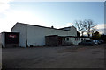
Aviemore Village Hall
Located just on Grampian Road at the north end of the village. Not the prettiest of buildings.
Image: © Phil Champion
Taken: 11 Oct 2011
0.10 miles
10
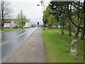
Milestone on Grampian Road, Aviemore
A milestone on Grampian Road in the town of Aviemore, in the Highlands of Scotland. This area lies within the Cairngorms National Park.
The road used to be part of the trunk A9, taking traffic through the town. The A9 now by-passes Aviemore and this road has been reclassified as the B9152. The road is on the route of the Speyside Way long distance path.
Image: © Malc McDonald
Taken: 23 Apr 2023
0.11 miles