IMAGES TAKEN NEAR TO
Dunning, PERTH, PH2 0QL
Introduction
This page details the photographs taken nearby to PH2 0QL by members of the Geograph project.
The Geograph project started in 2005 with the aim of publishing, organising and preserving representative images for every square kilometre of Great Britain, Ireland and the Isle of Man.

There are currently over 7.5m images from over14,400 individuals and you can help contribute to the project by visiting https://www.geograph.org.uk
Image Map
Images are licensed for reuse under creativecommons.org/licenses/by-sa/2.0
Notes
- Clicking on the map will re-center to the selected point.
- The higher the marker number, the further away the image location is from the centre of the postcode.
Image Listing (5 Images Found)
Images are licensed for reuse under creativecommons.org/licenses/by-sa/2.0
Image
Details
Distance
1
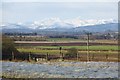
Strath Earn
The Glasgow to Aberdeen railway passes a field of turnips growing under netting. There is a fine backdrop of Ben Vorlich and Stuc a' Chroin with heavy snow cover.
Image: © Richard Webb
Taken: 1 Feb 2015
0.13 miles
2
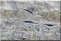
Turnips under netting, Wester Balgour
A crop protected by netting.
Image: © Richard Webb
Taken: 1 Feb 2015
0.14 miles
3
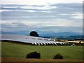
Fruit Farm
On the slopes above the Earn Valley with the Crieff hills in the distance.
Image: © Lis Burke
Taken: 9 Jul 2005
0.16 miles
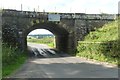
5
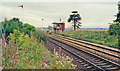
Site of former Dunning station, 1991
View Sw, towards Stirling and Glasgow: ex-Caledonian Railway Glasgow - Stirling - Perth etc. main line. The station, which was about two miles from Dunning, had been closed to passengers 11/6/56, to goods 7/9/64 - but a new signalbox seems to be provided.
Image: © Ben Brooksbank
Taken: 5 Sep 1991
0.19 miles