IMAGES TAKEN NEAR TO
Rannoch, PITLOCHRY, PH17 2QP
Introduction
This page details the photographs taken nearby to PH17 2QP by members of the Geograph project.
The Geograph project started in 2005 with the aim of publishing, organising and preserving representative images for every square kilometre of Great Britain, Ireland and the Isle of Man.

There are currently over 7.5m images from over14,400 individuals and you can help contribute to the project by visiting https://www.geograph.org.uk
Image Map
Images are licensed for reuse under creativecommons.org/licenses/by-sa/2.0
Notes
- Clicking on the map will re-center to the selected point.
- The higher the marker number, the further away the image location is from the centre of the postcode.
Image Listing (25 Images Found)
Images are licensed for reuse under creativecommons.org/licenses/by-sa/2.0
Image
Details
Distance
1
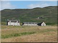
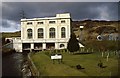
Farmhouse and farm buildings at Ardlarach
Image: © Alpin Stewart
Taken: 13 Aug 2015
0.01 miles
2
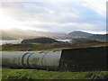
Water Pipes above Loch Rannoch
These massive pipes carry water from the valve house to Rannoch power station.
Image: © Robert Struthers
Taken: 4 Jan 2007
0.12 miles
4
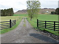
Track leading to Ardlarach
Looking north-westward.
Image: © Peter Wood
Taken: 28 Apr 2019
0.13 miles
5
Pipeline to Rannoch Power Station
These massive pipes supply water to the power station.
Image: © Robert Struthers
Taken: 4 Jan 2007
0.13 miles
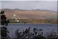
6
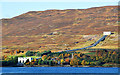
Rannoch Power Station
On the north shore of Loch Rannoch. This is part of the Tummel-Garry Hydroelectric Scheme. The high pressure pipeline brings water via tunnel from Loch Ericht and aqueducts on the north side of Loch Rannoch. Installed capacity 48MW, operating head 512 feet.
Image: © Dr Richard Murray
Taken: 16 Oct 2009
0.14 miles
8

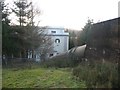
Rannoch hydro-electric power station
In operation since 1930 Rannoch hydro-electric power station gets its water from Loch Ericht which is four miles or so to its north. The water reaches the power station by a system of tunnels and pipes the latter part of which is visible on the hillside above the power station Image Producing 44.1MW of electricity this power station is part of the Tummel Valley Scheme which consists of nine different power stations some of which 'share' water which flows from one reservoir to another.
Image: © Bill Kasman
Taken: 23 Jun 2019
0.15 miles
9
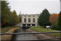
Rannoch Power Station
The penstock pipelines bringing the water down from Tom an Stòil are visible in the background.
Image: © Russel Wills
Taken: Unknown
0.15 miles
10
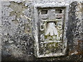
Ordnance Survey Flush Bracket S7775
This bracket can be found on the wall of a building at Rannoch Power Station. The benchmark height has been calculated as 209.645 metres above sea level.
For more detail see : https://www.bench-marks.org.uk/bm21101
Image: © Peter Wood
Taken: 28 Apr 2019
0.15 miles