IMAGES TAKEN NEAR TO
Nursing Home Brae, PITLOCHRY, PH16 5HP
Introduction
This page details the photographs taken nearby to Nursing Home Brae, PH16 5HP by members of the Geograph project.
The Geograph project started in 2005 with the aim of publishing, organising and preserving representative images for every square kilometre of Great Britain, Ireland and the Isle of Man.

There are currently over 7.5m images from over14,400 individuals and you can help contribute to the project by visiting https://www.geograph.org.uk
Image Map
Images are licensed for reuse under creativecommons.org/licenses/by-sa/2.0
Notes
- Clicking on the map will re-center to the selected point.
- The higher the marker number, the further away the image location is from the centre of the postcode.
Image Listing (37 Images Found)
Images are licensed for reuse under creativecommons.org/licenses/by-sa/2.0
Image
Details
Distance
1
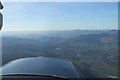
Aerial Photo of Pitlochry
Picture taken from a Cessna 152 "G-TFCI" at altitude 2500' on the 4th of April 2007 during a navigation exercise.
Image: © alistair cameron
Taken: 4 Apr 2007
0.08 miles
2
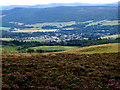
Pitlochry Town
Pitlochry from the Bealach Walk
Image: © Ian Mockford
Taken: 2 Aug 2006
0.08 miles

4
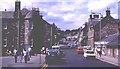
Atholl Road, Pitlochry
This is the main street of the town of Pitlochry. Library on the left.
Image: © Anne Burgess
Taken: Unknown
0.09 miles
5
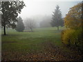
Park: Pitlochry
Between East Moulin Road and Tom-na-Moan Road
Image: © Jim Smillie
Taken: 6 Nov 2010
0.10 miles
6
Tom-na-Moan Road meets East Moulin Road
Modern housing contrasting with more traditional type.
Image: © Jim Smillie
Taken: 6 Nov 2010
0.10 miles
10
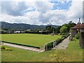
Bowling green
Bonnethill Road, Pitlochry
Image: © Richard Webb
Taken: 24 Jul 2013
0.18 miles