IMAGES TAKEN NEAR TO
ABERFELDY, PH15 2NB
Introduction
This page details the photographs taken nearby to PH15 2NB by members of the Geograph project.
The Geograph project started in 2005 with the aim of publishing, organising and preserving representative images for every square kilometre of Great Britain, Ireland and the Isle of Man.

There are currently over 7.5m images from over14,400 individuals and you can help contribute to the project by visiting https://www.geograph.org.uk
Image Map
Images are licensed for reuse under creativecommons.org/licenses/by-sa/2.0
Notes
- Clicking on the map will re-center to the selected point.
- The higher the marker number, the further away the image location is from the centre of the postcode.
Image Listing (8 Images Found)
Images are licensed for reuse under creativecommons.org/licenses/by-sa/2.0
Image
Details
Distance
1
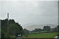
Field at the edge of Dull Wood
With farmland in the Appin of Dull beyond. In the right background is the southern edge of forested Drummond Hill.
Image: © Dr Richard Murray
Taken: 13 Aug 2009
0.09 miles
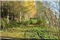
2
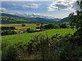
Farmland, Dull
View out of the woods towards Drummond Hill.
Image: © Richard Webb
Taken: 8 Nov 2014
0.09 miles
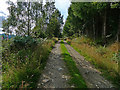
3
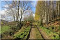
Forest Track in Dull Wood
Running along the edge of the wood at the start of a set of long zigzags up the very steep slopes above Dull.
Image: © Richard Webb
Taken: 8 Nov 2014
0.11 miles
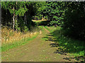
4
Forest Track in Dull Wood
On the southern edge of the wood, one of a network of tracks also used as footpaths.
Image: © Dr Richard Murray
Taken: 13 Aug 2009
0.13 miles
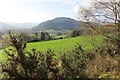
5
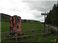
Water tank, Wester Carse
Water tank and farm sign, Dull.
Image: © Richard Webb
Taken: 13 May 2007
0.13 miles
6
Forest Track in Dull Wood
The same path as Image This is a core path from Dull or Camserney.
Image: © Richard Webb
Taken: 8 Nov 2014
0.19 miles
7
Forest Track in Dull Wood
Looking east, towards Dull.
Image: © Dr Richard Murray
Taken: 13 Aug 2009
0.20 miles