IMAGES TAKEN NEAR TO
Keltneyburn, ABERFELDY, PH15 2LG
Introduction
This page details the photographs taken nearby to PH15 2LG by members of the Geograph project.
The Geograph project started in 2005 with the aim of publishing, organising and preserving representative images for every square kilometre of Great Britain, Ireland and the Isle of Man.

There are currently over 7.5m images from over14,400 individuals and you can help contribute to the project by visiting https://www.geograph.org.uk
Image Map
Images are licensed for reuse under creativecommons.org/licenses/by-sa/2.0
Notes
- Clicking on the map will re-center to the selected point.
- The higher the marker number, the further away the image location is from the centre of the postcode.
Image Listing (10 Images Found)
Images are licensed for reuse under creativecommons.org/licenses/by-sa/2.0
Image
Details
Distance
1
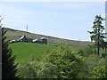
Wester Litigan
A farm high above the Keltney Burn which flows through a steep sided gorge here.
Image: © Richard Webb
Taken: 23 May 2012
0.01 miles
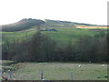
2

Litigan, perched high above the Keltney gorge
Image: © Alan Reid
Taken: 18 Jun 2018
0.02 miles
4
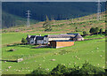
Litigan
A long-lens view of the farm buildings at Litigan. Note the horse mill - the circular building on the right. These were used for threshing grain. A horse was harnessed to a beam and walked round and round and round inside the mill, driving the millstones. See https://en.wikipedia.org/wiki/Horse_mill for a more detailed description.
Image: © Anne Burgess
Taken: 8 Jul 2024
0.03 miles
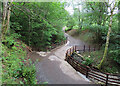
5
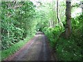
Garth track
Looking down the track in the direction of Keltneyburn.
Image: © Callum Black
Taken: 12 Jun 2006
0.15 miles
6
Bridge to Inchgarth
The bridge spans Allt Coire Pheiginn shortly before its confluence with the Keltney Burn.
Image: © Anne Burgess
Taken: 9 Jul 2024
0.23 miles
7
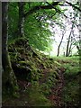
Beech trees
Beech trees, roots and moss by the track to Garth Castle.
Image: © Callum Black
Taken: 12 Jun 2006
0.23 miles
8
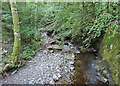
Allt Coire Pheiginn
Looking downstream from the bridge to Inchgarth.
Image: © Anne Burgess
Taken: 8 Jul 2024
0.23 miles
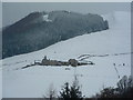
10
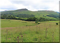
Grassland near Garth
Looking down towards tghe gorge of the Keltney Burn. I think the prominent distant hill is Creag Odhar (523 metres)
Image: © Anne Burgess
Taken: 9 Jul 2024
0.24 miles