IMAGES TAKEN NEAR TO
ABERFELDY, PH15 2JL
Introduction
This page details the photographs taken nearby to PH15 2JL by members of the Geograph project.
The Geograph project started in 2005 with the aim of publishing, organising and preserving representative images for every square kilometre of Great Britain, Ireland and the Isle of Man.

There are currently over 7.5m images from over14,400 individuals and you can help contribute to the project by visiting https://www.geograph.org.uk
Image Map
Images are licensed for reuse under creativecommons.org/licenses/by-sa/2.0
Notes
- Clicking on the map will re-center to the selected point.
- The higher the marker number, the further away the image location is from the centre of the postcode.
Image Listing (7 Images Found)
Images are licensed for reuse under creativecommons.org/licenses/by-sa/2.0
Image
Details
Distance
1
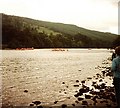
Raft Race
Watching the raft race from Kenmore to Aberfeldy on the River Tay.
Image: © Gerald England
Taken: 27 Jun 1982
0.11 miles
2
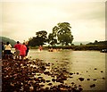
Raft Race
Watching the raft race from Kenmore to Aberfeldy on the River Tay.
Image: © Gerald England
Taken: 27 Jun 1982
0.14 miles
3
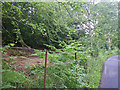
Densely forested native woodland south of the A827 Road
Image: © C Michael Hogan
Taken: 10 Jul 2010
0.19 miles
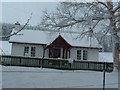
5

Frost-covered trees, Bolfracks
Beside the River Tay the trees are encrusted with thick hoar frost on a day when temperatures in the area barely rose above - 10 degrees Celsius.
Image: © Mike Pennington
Taken: 29 Dec 2009
0.22 miles
6
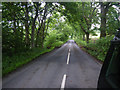
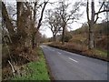
Looking along the A827
Photographer is standing on the roadway pavement. The forest begins to thin out slightly along the southern roadway verge, unlike the dense woodland associated with NN8147 at the south of the A827.
Image: © C Michael Hogan
Taken: 10 Jul 2010
0.22 miles