IMAGES TAKEN NEAR TO
Crieff Road, ABERFELDY, PH15 2FJ
Introduction
This page details the photographs taken nearby to Crieff Road, PH15 2FJ by members of the Geograph project.
The Geograph project started in 2005 with the aim of publishing, organising and preserving representative images for every square kilometre of Great Britain, Ireland and the Isle of Man.

There are currently over 7.5m images from over14,400 individuals and you can help contribute to the project by visiting https://www.geograph.org.uk
Image Map
Images are licensed for reuse under creativecommons.org/licenses/by-sa/2.0
Notes
- Clicking on the map will re-center to the selected point.
- The higher the marker number, the further away the image location is from the centre of the postcode.
Image Listing (121 Images Found)
Images are licensed for reuse under creativecommons.org/licenses/by-sa/2.0
Image
Details
Distance
1
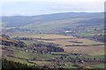
Appin of Dull
The flat floor of Strath Tay and Aberfeldy seen from the road beside Rock of Dull.
Image: © Richard Webb
Taken: 8 Nov 2014
0.03 miles
2
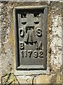
OS Flush Bracket 11792 on former Church of Scotland, Aberfeldy
OS FLUSH BRACKET: NBM FL BR 11792 CH OF SCOTLAND S FACE SE ANG (ODN 107.7830m, AGL 0.3m).
Image: © thejackrustles
Taken: 23 May 2018
0.07 miles
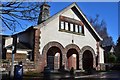
3
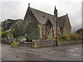
The Kirk, Aberfeldy
The former Aberfeldy Church, on Crieff Road, is being converted into residential apartments.
Image: © David Dixon
Taken: 24 Oct 2011
0.08 miles
4
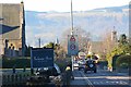
Crieff Road, Aberfeldy
Aberfeldy seems like a big city after the rural walk following the Rob Roy Way from Acharn.
Image: © Jim Barton
Taken: 17 Mar 2016
0.08 miles
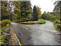
6
Aberfeldy Town Hall
The Town Hall in Crieff Road, used as a venue for entertainment, meetings and events.
Image: © Jim Barton
Taken: 19 Feb 2015
0.11 miles
7

OS Cut Mark: Aberfeldy, Town Hall
CUT MARK: The W face SW corner (ODN 103.2950m, AGL 0.2m).
Image: © thejackrustles
Taken: 23 May 2018
0.11 miles
8
Footbridge over mill lade, Aberfeldy
The lade took water from the Moness Burn to the mill to the north of the main street. The path continues to the town.
Image: © Jim Barton
Taken: 19 Feb 2015
0.11 miles
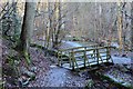
9
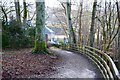
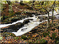
Lower path, Birks of Aberfeldy
The path to Aberfeldy alongside the Moness Burn continues on the N side of the A826 road.
Image: © Jim Barton
Taken: 19 Feb 2015
0.11 miles