IMAGES TAKEN NEAR TO
Murthly, PERTH, PH1 4HX
Introduction
This page details the photographs taken nearby to PH1 4HX by members of the Geograph project.
The Geograph project started in 2005 with the aim of publishing, organising and preserving representative images for every square kilometre of Great Britain, Ireland and the Isle of Man.

There are currently over 7.5m images from over14,400 individuals and you can help contribute to the project by visiting https://www.geograph.org.uk
Image Map (Loading...)


Getting Data...Please wait
Leaflet Map data © OpenStreetMap
Images are licensed for reuse under creativecommons.org/licenses/by-sa/2.0
Notes
- Clicking on the map will re-center to the selected point.
- The higher the marker number, the further away the image location is from the centre of the postcode.
Image Listing (9 Images Found)
Images are licensed for reuse under creativecommons.org/licenses/by-sa/2.0
Image
Details
Distance


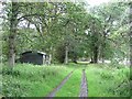
4

Edge of an oak wood
A small open oak wood with a grassy floor occupies a steep bit of a field.
Image: © Richard Webb
Taken: 18 Jul 2011
0.10 miles
5
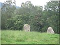
Standing stones
Two standing stones near Staredam.
Image: © Richard Webb
Taken: 18 Jul 2011
0.11 miles
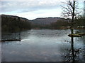
7
Woodland, Stare Dam
Lochside woodland.
Image: © Richard Webb
Taken: 18 Jul 2011
0.18 miles
9
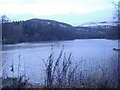
Stare Dam, Rohallion Loch
Taken towards dusk which is why it's sub-fusc. Where the texture of the surface changes, in the middle of the loch, the surface is actually frozen.
Image: © Kirsty Smith
Taken: 25 Nov 2005
0.24 miles