IMAGES TAKEN NEAR TO
Perth Road, PERTH, PH1 4AF
Introduction
This page details the photographs taken nearby to Perth Road, PH1 4AF by members of the Geograph project.
The Geograph project started in 2005 with the aim of publishing, organising and preserving representative images for every square kilometre of Great Britain, Ireland and the Isle of Man.

There are currently over 7.5m images from over14,400 individuals and you can help contribute to the project by visiting https://www.geograph.org.uk
Image Map
Images are licensed for reuse under creativecommons.org/licenses/by-sa/2.0
Notes
- Clicking on the map will re-center to the selected point.
- The higher the marker number, the further away the image location is from the centre of the postcode.
Image Listing (28 Images Found)
Images are licensed for reuse under creativecommons.org/licenses/by-sa/2.0
Image
Details
Distance
1
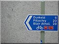
Sign, National Cycle Network route 77
Route 77 links Dundee with route 7 at Ballinluig. It follows the River Tay.
Image: © Richard Webb
Taken: 18 Jul 2011
0.04 miles
2
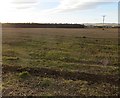
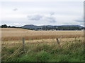
Stubble, Bankfoot
A very large barley field.
Image: © Richard Webb
Taken: 30 Nov 2013
0.08 miles
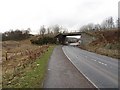
3
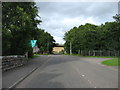
Minor road to Murthly, leaving Bankfoot
The bridge ahead carries the A9 past the village.
Oh! how the Scottish Government must wish that the A9 had been dualled all the way from Perth to Inverness when it was first improved. The extensive two-lane stretches are usually long, sweeping bends with inadequate visibility to overtake when oncoming traffic is also doing at least 60mph (to say nothing of the fact that the road is now so busy that there are rarely any gaps). It is gradually being upgraded but this must be an expensive process - also painfully slow, a bit like driving along it often is.
Image: © David Purchase
Taken: 30 Aug 2015
0.09 miles
4
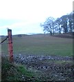
Field entrance, near Bankfoot
from opposite where the hotel used to be.
Image: © Kirsty Smith
Taken: 25 Nov 2005
0.09 miles
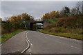
5
Bridge under the A9
This bridge has now been incorporated into a split-level junction which has removed the lethal right turn at Bankfoot.
Image: © Richard Webb
Taken: 15 Feb 2011
0.10 miles
7
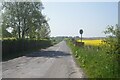
Road off the B867 towards east Nether Blelock
Image: © Ian S
Taken: 30 May 2021
0.10 miles
8
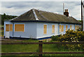
Bankfoot railway station
At this point in time the old station yard appeared to be in use as a caravan park; the station building seemed in reasonable condition despite being boarded up.
Image: © Nigel Brown
Taken: 10 Jun 1995
0.10 miles
10
Cereal crop in field south of Bankfoot
Image: © nick macneill
Taken: 4 Sep 2011
0.14 miles