IMAGES TAKEN NEAR TO
Brora Court, PERTH, PH1 3DQ
Introduction
This page details the photographs taken nearby to Brora Court, PH1 3DQ by members of the Geograph project.
The Geograph project started in 2005 with the aim of publishing, organising and preserving representative images for every square kilometre of Great Britain, Ireland and the Isle of Man.

There are currently over 7.5m images from over14,400 individuals and you can help contribute to the project by visiting https://www.geograph.org.uk
Image Map
Images are licensed for reuse under creativecommons.org/licenses/by-sa/2.0
Notes
- Clicking on the map will re-center to the selected point.
- The higher the marker number, the further away the image location is from the centre of the postcode.
Image Listing (9 Images Found)
Images are licensed for reuse under creativecommons.org/licenses/by-sa/2.0
Image
Details
Distance
2
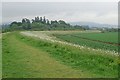
Flood barrier
The new post 1993 flood barrier protecting North Muirton in the distance and the industrial estates around the Inveralmond area.
Image: © Jim Bain
Taken: 8 Jun 2007
0.19 miles
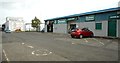
3

Morgan Three Wheeler
Morgan on display near showroom in Perth.
Image: © Mary Rodgers
Taken: 4 Jul 2019
0.19 miles
4

Tile showroom
Jewson ceramic tile distributors tile showroom on Arran Road in North Muirton Industrial Estate.
Image: © Richard Sutcliffe
Taken: 5 Oct 2019
0.20 miles
5
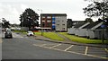
Flats on Argyll Road
Looking across Bute Drive.
Image: © Richard Sutcliffe
Taken: 5 Oct 2019
0.20 miles
7
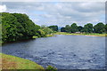
Woody Island
On the left bank of the Tay is Woody Island, and on the right is Scone Park.
Image: © william
Taken: 13 Jul 2010
0.22 miles
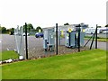
8
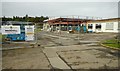
Construction work
Strathmore Volvo are having work done to their car showrooms.
Image: © Richard Sutcliffe
Taken: 5 Oct 2019
0.23 miles
9

Woody island in winter
The heavy snowfall from late November, supplemented by further snow, had only thawed slightly but the additional water in the Tay was causing a powerful current close to the west bank.
Image: © Lis Burke
Taken: 11 Dec 2010
0.25 miles