IMAGES TAKEN NEAR TO
High Street, BLAIRGOWRIE, PH13 9NS
Introduction
This page details the photographs taken nearby to High Street, PH13 9NS by members of the Geograph project.
The Geograph project started in 2005 with the aim of publishing, organising and preserving representative images for every square kilometre of Great Britain, Ireland and the Isle of Man.

There are currently over 7.5m images from over14,400 individuals and you can help contribute to the project by visiting https://www.geograph.org.uk
Image Map
Images are licensed for reuse under creativecommons.org/licenses/by-sa/2.0
Notes
- Clicking on the map will re-center to the selected point.
- The higher the marker number, the further away the image location is from the centre of the postcode.
Image Listing (17 Images Found)
Images are licensed for reuse under creativecommons.org/licenses/by-sa/2.0
Image
Details
Distance
1
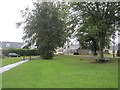
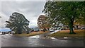
Burrelton
A green space between the High Street and Scott Street.
Image: © Richard Webb
Taken: 16 Sep 2012
0.05 miles
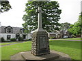
2
War memorial in Burrelton
The centre of the small village of Burrelton has several grassed areas; two are seen here, the farther one has the war memorial which is seen centrally. The memorial has the name Cargill, rather than that of the village.
Image: © Trevor Littlewood
Taken: 19 Oct 2018
0.05 miles
4
War Memorial at Burrelton
The war memorial by the A94 in Burrelton.
Image: © Scott Cormie
Taken: 17 Jun 2018
0.06 miles

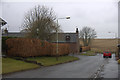
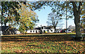
8
The end of Scott Street
The north-western end of Scott Street in the village of Burrelton where there's a bungalow and a footbridge over the Wellsies Burn which gives a way on to the Millennium Footpath, a 'core path' of the settlement.
Image: © Trevor Littlewood
Taken: 19 Oct 2018
0.13 miles
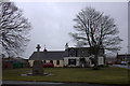
9
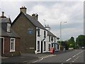
High Street Burrelton
Cathkin Tavern beside the High Street (A94)
Image: © Richard Webb
Taken: 17 Jun 2005
0.13 miles
10
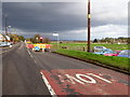
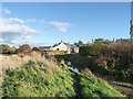
Road works, Woodside
Road works on the A94.
Image: © Maigheach-gheal
Taken: 31 Oct 2011
0.14 miles