IMAGES TAKEN NEAR TO
Perth Road, BLAIRGOWRIE, PH13 9LZ
Introduction
This page details the photographs taken nearby to Perth Road, PH13 9LZ by members of the Geograph project.
The Geograph project started in 2005 with the aim of publishing, organising and preserving representative images for every square kilometre of Great Britain, Ireland and the Isle of Man.

There are currently over 7.5m images from over14,400 individuals and you can help contribute to the project by visiting https://www.geograph.org.uk
Image Map
Images are licensed for reuse under creativecommons.org/licenses/by-sa/2.0
Notes
- Clicking on the map will re-center to the selected point.
- The higher the marker number, the further away the image location is from the centre of the postcode.
Image Listing (7 Images Found)
Images are licensed for reuse under creativecommons.org/licenses/by-sa/2.0
Image
Details
Distance
1
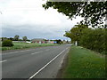
Entering Coupar Angus from Perth
The main A94 road coming into Coupar Angus from the south.
Image: © James Allan
Taken: 7 May 2007
0.07 miles
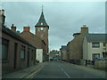
2
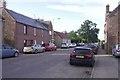
George Street, Coupar Angus
Once the A94, that road now runs along the trackbed of the Caledonian Railway.
Image: © Richard Webb
Taken: 13 Sep 2019
0.13 miles
3
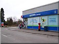
Scotmid, Coupar Angus
The store is very popular and also houses the post office and there is a George V reign postbox outside.
Image: © Maigheach-gheal
Taken: 31 Mar 2010
0.13 miles
4
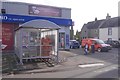
Co-op, Coupar Angus
Also home of the post office, on George Street.
Image: © Richard Webb
Taken: 13 Sep 2019
0.15 miles
6
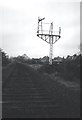
Dismantling the Caledonian Railway
In Coupar Angus. Taken on the way to a football match in Brechin. The trackbed is now the A94. Image
Image: © Richard Webb
Taken: 1 May 1983
0.24 miles
7
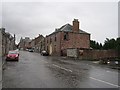
George Street
The old main road through Coupar Angus.
Image: © Richard Webb
Taken: 16 Sep 2012
0.25 miles