IMAGES TAKEN NEAR TO
Coupar Angus, BLAIRGOWRIE, PH13 9HN
Introduction
This page details the photographs taken nearby to PH13 9HN by members of the Geograph project.
The Geograph project started in 2005 with the aim of publishing, organising and preserving representative images for every square kilometre of Great Britain, Ireland and the Isle of Man.

There are currently over 7.5m images from over14,400 individuals and you can help contribute to the project by visiting https://www.geograph.org.uk
Image Map
Images are licensed for reuse under creativecommons.org/licenses/by-sa/2.0
Notes
- Clicking on the map will re-center to the selected point.
- The higher the marker number, the further away the image location is from the centre of the postcode.
Image Listing (4 Images Found)
Images are licensed for reuse under creativecommons.org/licenses/by-sa/2.0
Image
Details
Distance
1
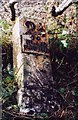
Old Milestone by the A923, Old Military Road, Blairgowrie Parish
By the A923, in parish of Blairgowrie (Perth and Kinross District), South of Rosemount, Bennathie, in hedgerow.
Inscription reads:- : 2¾ / TO / BLAIR / GOWRIE : : 2 / COUPAR / ANGUS :
Surveyed
Milestone Society National ID: PK_BGCA03
Image: © Milestone Society
Taken: Unknown
0.08 miles
3
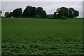
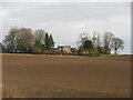
Hills of Bendochy
Farm amidst potato fields on the north bank of the Isla.
Image: © Mike Pennington
Taken: 18 Jul 2008
0.23 miles
4
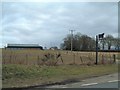
Hills of Bendochy
Looking northwards to the Hills of Bendochy from the A923 junction with the Bendochy road.
Image: © Scott Cormie
Taken: 6 Apr 2022
0.25 miles