IMAGES TAKEN NEAR TO
Strathord Terrace, PERTH, PH1 2ED
Introduction
This page details the photographs taken nearby to Strathord Terrace, PH1 2ED by members of the Geograph project.
The Geograph project started in 2005 with the aim of publishing, organising and preserving representative images for every square kilometre of Great Britain, Ireland and the Isle of Man.

There are currently over 7.5m images from over14,400 individuals and you can help contribute to the project by visiting https://www.geograph.org.uk
Image Map (Loading...)


Getting Data...Please wait
Leaflet Map data © OpenStreetMap
Images are licensed for reuse under creativecommons.org/licenses/by-sa/2.0
Notes
- Clicking on the map will re-center to the selected point.
- The higher the marker number, the further away the image location is from the centre of the postcode.
Image Listing (7 Images Found)
Images are licensed for reuse under creativecommons.org/licenses/by-sa/2.0
Image
Details
Distance
1
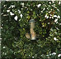
Holly bush bird feeder
Keeping the birds happy for Christmas dinner.
Image: © Jackie Proven
Taken: 25 Dec 2010
0.09 miles
2
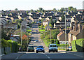
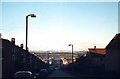
Campsie Rd Letham
My great granny lived at the bottom of the hill.
Image: © william
Taken: 8 Sep 2011
0.19 miles
6
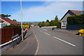
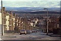
North on Newhouse Road, Letham, Perth, February 1979
The southern leg of Newhouse Road is dramatically steep, the council flats crowstepping down to the roundabout and the junction with Rannoch Road. The view is across the valley of the River Almond to snow-covered hills on the southern edge of the highlands. Moulin Crescent is the turning on the right. There is farmland behind the flats on the left; now it is housing estates and the A9.
Image: © Robin Stott
Taken: Unknown
0.24 miles
7
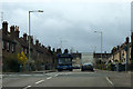
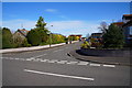
North on Newhouse Road, Letham, Perth, April 1979
In 1979 this was the western edge of Perth; there was farmland, Letham Farm, behind the cliff of council flats on the left: Image Now, housing estates extend west to the A9 dual carriageway: Image gives a flavour. The roundabout ahead, in NO0824, is at the top of Rannoch Road. The view, from the junction with Burghmuir Road, right, continues across the valley of the River Almond and the wooded ridge to its north, to the slopes that mark the southern edge of the Highlands. Snow still covers the distant Perthshire hills.
Scanned from a Kodak Ektachrome slide, reference 79·04·18 (year, film, frame).
Image: © Robin Stott
Taken: 15 Apr 1979
0.25 miles