North on Newhouse Road, Letham, Perth, April 1979
Introduction
The photograph on this page of North on Newhouse Road, Letham, Perth, April 1979 by Robin Stott as part of the Geograph project.
The Geograph project started in 2005 with the aim of publishing, organising and preserving representative images for every square kilometre of Great Britain, Ireland and the Isle of Man.

There are currently over 7.5m images from over 14,400 individuals and you can help contribute to the project by visiting https://www.geograph.org.uk
North on Newhouse Road, Letham, Perth, April 1979
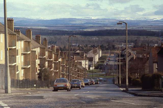
Image: © Robin Stott Taken: 15 Apr 1979
In 1979 this was the western edge of Perth; there was farmland, Letham Farm, behind the cliff of council flats on the left: Image Now, housing estates extend west to the A9 dual carriageway: Image gives a flavour. The roundabout ahead, in NO0824, is at the top of Rannoch Road. The view, from the junction with Burghmuir Road, right, continues across the valley of the River Almond and the wooded ridge to its north, to the slopes that mark the southern edge of the Highlands. Snow still covers the distant Perthshire hills. Scanned from a Kodak Ektachrome slide, reference 79·04·18 (year, film, frame).
Images are licensed for reuse under creativecommons.org/licenses/by-sa/2.0
Image Location
Latitude
56.39907
Longitude
-3.4782