IMAGES TAKEN NEAR TO
Mackintosh Way, PERTH, PH1 1SL
Introduction
This page details the photographs taken nearby to Mackintosh Way, PH1 1SL by members of the Geograph project.
The Geograph project started in 2005 with the aim of publishing, organising and preserving representative images for every square kilometre of Great Britain, Ireland and the Isle of Man.

There are currently over 7.5m images from over14,400 individuals and you can help contribute to the project by visiting https://www.geograph.org.uk
Image Map
Images are licensed for reuse under creativecommons.org/licenses/by-sa/2.0
Notes
- Clicking on the map will re-center to the selected point.
- The higher the marker number, the further away the image location is from the centre of the postcode.
Image Listing (16 Images Found)
Images are licensed for reuse under creativecommons.org/licenses/by-sa/2.0
Image
Details
Distance

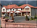
2
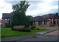
Perth Baptist Church Centre
This modern church centre is in the middle of a residential district on the western edge of Perth.
Image: © Lis Burke
Taken: 16 Aug 2007
0.15 miles
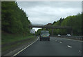
3
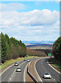
A90 west of Perth
The A90 to the west of Perth, viewed from the access road to Noah's Ark activity centre.
Image: © William Starkey
Taken: 18 Mar 2012
0.18 miles
6
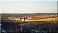
Western side of Newhouse Road, Letham, Perth, late winter, 1979
We spent about 18 months in one of these council flats, no.39E, somewhere in the block left of centre whose gable end faces the camera. These flats enjoyed a superb view (and sunsets) to the west. The southern half of Newhouse Road, right, climbing a steep hill is truly dramatic. The viewpoint is probably from the Old Gallows Road at its junction with the track down to Letham Farm. The farmland is now blanketed by housing and the A9 road. Beyond Perth, the declivity between wooded hills marks the valley of the River Tay. Note the snow-covered hills in the distance.
Scanned from an Agfa CT18 colour slide, ref 79·01·23 (that's not the date taken); taken with a Zenith SLR.
Image: © Robin Stott
Taken: Unknown
0.21 miles
7
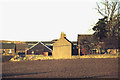
Letham Farm near Perth, late winter 1979
Photographed from a second-floor council flat, no.39E, on the west side of the Newhouse Road roundabout on what was then the western edge of Perth. It is now housing estates with the A9 beyond it.
Scanned from an Agfa CT18 slide, ref 79·01·17 (the 17th frame of the 1st film loaded in 1979); the camera was a Zenith SLR with three interchangeable lenses, 35, 55 and 135mm.
Image: © Robin Stott
Taken: Unknown
0.21 miles
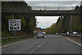
8
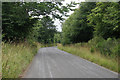
A9, Perth
Looking south towards the Old Gallows Road bridge.
Image: © JThomas
Taken: 10 May 2014
0.21 miles
9
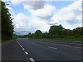
Perth : The A9
Heading through Perth on the A9.
Image: © Lewis Clarke
Taken: 25 Apr 2016
0.22 miles
10
New housing on the western edge of Perth
A lot of new houses have been built on this side of Perth in recent years.
Image: © Rob Burke
Taken: 19 Jul 2005
0.22 miles