Western side of Newhouse Road, Letham, Perth, late winter, 1979
Introduction
The photograph on this page of Western side of Newhouse Road, Letham, Perth, late winter, 1979 by Robin Stott as part of the Geograph project.
The Geograph project started in 2005 with the aim of publishing, organising and preserving representative images for every square kilometre of Great Britain, Ireland and the Isle of Man.

There are currently over 7.5m images from over 14,400 individuals and you can help contribute to the project by visiting https://www.geograph.org.uk
Western side of Newhouse Road, Letham, Perth, late winter, 1979
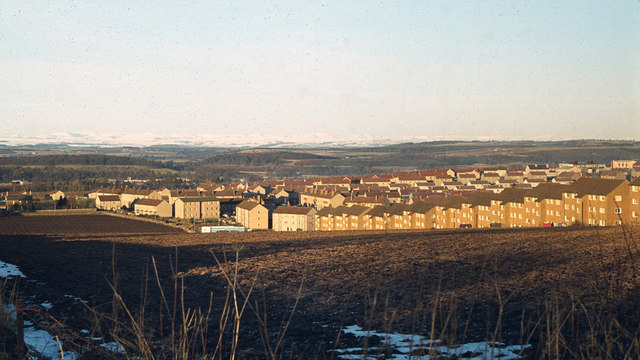
Image: © Robin Stott Taken: Unknown
We spent about 18 months in one of these council flats, no.39E, somewhere in the block left of centre whose gable end faces the camera. These flats enjoyed a superb view (and sunsets) to the west. The southern half of Newhouse Road, right, climbing a steep hill is truly dramatic. The viewpoint is probably from the Old Gallows Road at its junction with the track down to Letham Farm. The farmland is now blanketed by housing and the A9 road. Beyond Perth, the declivity between wooded hills marks the valley of the River Tay. Note the snow-covered hills in the distance. Scanned from an Agfa CT18 colour slide, ref 79·01·23 (that's not the date taken); taken with a Zenith SLR.
Images are licensed for reuse under creativecommons.org/licenses/by-sa/2.0
Image Location
Latitude
56.400316
Longitude
-3.47922