IMAGES TAKEN NEAR TO
Alyth, BLAIRGOWRIE, PH11 8LQ
Introduction
This page details the photographs taken nearby to PH11 8LQ by members of the Geograph project.
The Geograph project started in 2005 with the aim of publishing, organising and preserving representative images for every square kilometre of Great Britain, Ireland and the Isle of Man.

There are currently over 7.5m images from over14,400 individuals and you can help contribute to the project by visiting https://www.geograph.org.uk
Image Map
Images are licensed for reuse under creativecommons.org/licenses/by-sa/2.0
Notes
- Clicking on the map will re-center to the selected point.
- The higher the marker number, the further away the image location is from the centre of the postcode.
Image Listing (12 Images Found)
Images are licensed for reuse under creativecommons.org/licenses/by-sa/2.0
Image
Details
Distance
1
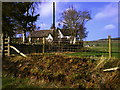
Gauldswell School
Formerly a school single classroom taking children from five to fourteen, converted to a dwelling in the 1960s.
Image: © Alisdair Mclean
Taken: 13 Apr 2007
0.02 miles
2
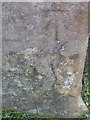
Bench Mark, Gauldswell Farm
The Ordnance Survey cut mark is to be found on the north face of the converted barn. For a wider view of the building Image and for further information on the cut mark and others in the area http://www.bench-marks.org.uk/bm39697
Image: © Maigheach-gheal
Taken: 10 Apr 2011
0.07 miles
3
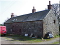
Former barn, Gauldswell Farm
The barn has been turned into a dwelling. There is an Ordnance Survey bench mark on the north face of the building.
Image: © Maigheach-gheal
Taken: 10 Apr 2011
0.08 miles
4
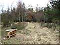
Gauldswell Wood
A clearing with a bird feeder. It is surrounded by a low level electric fence.
Image: © Richard Webb
Taken: 6 Mar 2011
0.14 miles
5
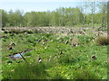
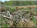
Wet woodland cleared by wild beavers
On the Bamff estate - the aspen,alder and willows were planted in 1992 and the ones in the foreground have been felled by beavers since they were introduced in 2002. http://www.bamff.co.uk/ http://www.scottishwildbeavers.org.
Image: © M J Richardson
Taken: 26 May 2012
0.14 miles
6
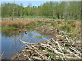
Beaver dam at Gauldswell Wood, Bamff
This area was a wet bog, but drained for agriculture in 1981. Trees [willow, aspen, alder and birch] were planted in 1992 and wild beavers introduced in 2002. The dam in the foreground is part of a 100m long dam, built by the beavers since then, that shows up on Google Earth http://www.bamff.co.uk/index.html , http://www.scottishwildbeavers.org. The trees in the distance are part of the original planting; the area with felled trees in the middle distance is covered with trees felled by the beavers for food and lodge-building, all the work of one family of perhaps 4-6 animals.
Image: © M J Richardson
Taken: 26 May 2012
0.14 miles
7
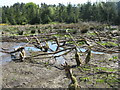
Beaver wetland at Bamff
A mud dam at the left is part of a 100m long dam made by the beavers, and all the stumps are the result of the activity of a wild beaver family. http://www.bamff.co.uk/ http://www.scottishwildbeavers.org.
Image: © M J Richardson
Taken: 26 May 2012
0.15 miles
8
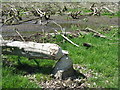
Alder felled by wild beavers at Bamff
Near a large dam created by the beavers Image http://www.bamff.co.uk , http://www.scottishwildbeavers.org
Image: © M J Richardson
Taken: 26 May 2012
0.15 miles
9
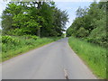
Minor road beside Gauldswell Wood
Looking north-westward from near the Woodland Skill Centre.
Image: © Peter Wood
Taken: 23 Jun 2019
0.17 miles
10
Beaver dam at Gauldswell Wood
Blocking a small stream flowing from the wood towards Bamff house and Alyth. There is a family of wild beavers looking after this area http://www.bamff.co.uk/ http://www.scottishwildbeavers.org.
Image: © M J Richardson
Taken: 26 May 2012
0.18 miles