IMAGES TAKEN NEAR TO
Blacklunans, BLAIRGOWRIE, PH10 7LR
Introduction
This page details the photographs taken nearby to PH10 7LR by members of the Geograph project.
The Geograph project started in 2005 with the aim of publishing, organising and preserving representative images for every square kilometre of Great Britain, Ireland and the Isle of Man.

There are currently over 7.5m images from over14,400 individuals and you can help contribute to the project by visiting https://www.geograph.org.uk
Image Map
Images are licensed for reuse under creativecommons.org/licenses/by-sa/2.0
Notes
- Clicking on the map will re-center to the selected point.
- The higher the marker number, the further away the image location is from the centre of the postcode.
Image Listing (6 Images Found)
Images are licensed for reuse under creativecommons.org/licenses/by-sa/2.0
Image
Details
Distance
1
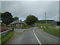
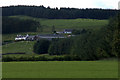
Glenkilrie cottages
By A93 in Glenshee.
Image: © Stanley Howe
Taken: 15 May 2014
0.00 miles
2
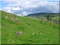
Glen Shee FBM
In a field of boulders, a concrete block.
This is part of the survey of Britain. The height of this block is known to great precision and connected to it are a series of levels all of known height. Benchmarks are to height, what trigpoints are to the other two dimensions.
FBM: Fundamental Bench Mark.
Image: © Richard Webb
Taken: 18 Jul 2004
0.12 miles
3
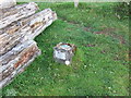
Ordnance Survey FBM Glenshee
This can be found in a field at Glenkilrie. The benchmark's height is recorded as 296.4 metres above sea level.
For more detail see : https://www.bench-marks.org.uk/bm1069
Image: © Peter Wood
Taken: 25 Jun 2019
0.13 miles
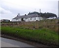
5
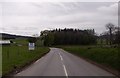
Glenkilrie Lodge
By A93 in Glenshee; offering B&B.
Image: © Stanley Howe
Taken: 15 May 2014
0.24 miles