IMAGES TAKEN NEAR TO
BLAIRGOWRIE, PH10 6TE
Introduction
This page details the photographs taken nearby to PH10 6TE by members of the Geograph project.
The Geograph project started in 2005 with the aim of publishing, organising and preserving representative images for every square kilometre of Great Britain, Ireland and the Isle of Man.

There are currently over 7.5m images from over14,400 individuals and you can help contribute to the project by visiting https://www.geograph.org.uk
Image Map
Images are licensed for reuse under creativecommons.org/licenses/by-sa/2.0
Notes
- Clicking on the map will re-center to the selected point.
- The higher the marker number, the further away the image location is from the centre of the postcode.
Image Listing (3 Images Found)
Images are licensed for reuse under creativecommons.org/licenses/by-sa/2.0
Image
Details
Distance
1
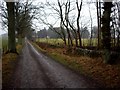
A93, Mains of Mause
A long tree lined section of the A93. There was not much traffic, but what there was was fast.
Image: © Richard Webb
Taken: 2 Oct 2016
0.18 miles
2
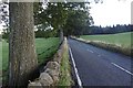
Trees lining Morganston Burn
The burn, obviously enough, is on the far side of the trees which also line the field on the north-east side of the A93.
Image: © Trevor Littlewood
Taken: 23 Oct 2018
0.21 miles