IMAGES TAKEN NEAR TO
Arthur Wynd, BLAIRGOWRIE, PH10 6PS
Introduction
This page details the photographs taken nearby to Arthur Wynd, PH10 6PS by members of the Geograph project.
The Geograph project started in 2005 with the aim of publishing, organising and preserving representative images for every square kilometre of Great Britain, Ireland and the Isle of Man.

There are currently over 7.5m images from over14,400 individuals and you can help contribute to the project by visiting https://www.geograph.org.uk
Image Map
Images are licensed for reuse under creativecommons.org/licenses/by-sa/2.0
Notes
- Clicking on the map will re-center to the selected point.
- The higher the marker number, the further away the image location is from the centre of the postcode.
Image Listing (35 Images Found)
Images are licensed for reuse under creativecommons.org/licenses/by-sa/2.0
Image
Details
Distance
1
Vehicle repair workshop, Blairgowrie
Occupying a town-centre position in Jessie Street, this is the premises of Walter A Crole and Son, car and commercial body repair centre. The photograph was taken on a Sunday, when the workshop was closed.
Image: © Richard Dorrell
Taken: 24 Feb 2013
0.09 miles
2
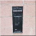
Black Victorian Wallbox
Black painted VR wallbox on the corner of the A93 Perth Road and A923 Dunkeld Road in Blairgowrie.
Image: © Scott Cormie
Taken: 24 Dec 2021
0.13 miles
4
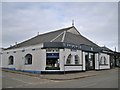
Car dealer's showroom, Blairgowrie
Located in Perth Street on the corner of Lochy Street. There are workshops attached at the rear. This part of the premises has the look of maybe having once been a hall or chapel.
Image: © Richard Dorrell
Taken: 24 Feb 2013
0.13 miles
5
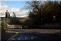
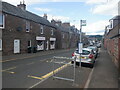
Crossroads on Bankhead, Blairgowrie
From Emma Street looking towards Back Brae across Bankhead.
Image: © Mike Pennington
Taken: 16 Oct 2011
0.14 miles
6
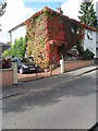
Virginia Creeper covered house, Bank Head, Blairgowrie
Image: © nick macneill
Taken: 4 Sep 2011
0.15 miles
8
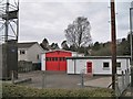
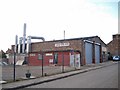
Fire station, Blairgowrie
Viewed from Lochy Street, this is the rear of the fire station, which faces West George Street. The building dates from 1956. The tower structure on the left is used for training purposes. Front of building: Image
Image: © Richard Dorrell
Taken: 24 Feb 2013
0.16 miles
9
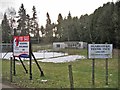
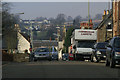
The signs say it all
An abandoned pavilion and snow-covered tennis courts are the now-disused Blairgowrie Tennis Club site. The land fronts onto Coupar Angus Road, close to the town centre, and the sign on the left clearly shows the site is currently for sale for residential development.
Image: © Richard Dorrell
Taken: 24 Feb 2013
0.16 miles
10
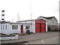
Fire station, Blairgowrie
Located in West George Street. The building was built in 1956 and officially opened on 2nd May 1958. The fire station has two front line appliances, a fully equipped rescue pump and a water tender ladder which are staffed by personnel employed on the retained duty system. The current establishment for the station is a Watch Manager, 3 x Crew Managers and 16 firefighters. Rear of building: Image
Image: © Richard Dorrell
Taken: 24 Feb 2013
0.17 miles