IMAGES TAKEN NEAR TO
Brown Street, BLAIRGOWRIE, PH10 6EX
Introduction
This page details the photographs taken nearby to Brown Street, PH10 6EX by members of the Geograph project.
The Geograph project started in 2005 with the aim of publishing, organising and preserving representative images for every square kilometre of Great Britain, Ireland and the Isle of Man.

There are currently over 7.5m images from over14,400 individuals and you can help contribute to the project by visiting https://www.geograph.org.uk
Image Map
Images are licensed for reuse under creativecommons.org/licenses/by-sa/2.0
Notes
- Clicking on the map will re-center to the selected point.
- The higher the marker number, the further away the image location is from the centre of the postcode.
Image Listing (212 Images Found)
Images are licensed for reuse under creativecommons.org/licenses/by-sa/2.0
Image
Details
Distance
1
St Catherine's Scottish Episcopal Church
Located on the corner of Brown Street and George Street. The chapel is dated 1842. Attached (the pinkish coloured building) is St Catherine's Community Centre - a purpose built Community Centre which opened in 2004.
Image: © Richard Dorrell
Taken: 24 Feb 2013
0.02 miles
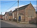
2
Brown Street, Blairgowrie
An elegant house stands at the cul-de-sac end of Brown Street, close to Blairgowrie town centre. The house is believed to date from 1832.
Image: © Richard Dorrell
Taken: 24 Feb 2013
0.04 miles
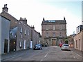
3
Former Mechanics Institute and Library, Blairgowrie
Dates from 1870 http://www.britishlistedbuildings.co.uk/sc-22296-31-37-odd-nos-high-street-former-institut Now in commercial and residential use.
Image: © Jonathan Thacker
Taken: 4 Dec 2013
0.05 miles
4
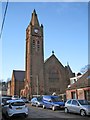
Parish Church, Blairgowrie
Located in James Street, and seen from the corner of George Street.
Image: © Richard Dorrell
Taken: 24 Feb 2013
0.05 miles
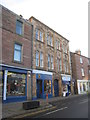
5
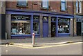
Piob Mhor of Scotland
An established Highland outfitters and Highland dance manufacturers since 1979. They are traditional kilt makers and hire out Highland dress and kilts. They also sell tartans and tweed and Scottish-made gifts. The building on High Street is Category C listed https://portal.historicenvironment.scot/designation/LB49429.
Image: © Richard Sutcliffe
Taken: 31 Oct 2023
0.05 miles
6
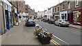
High Street, Blairgowrie
For the past few years this has been a one way street.
Image: © Richard Webb
Taken: 6 Sep 2013
0.06 miles
7
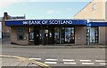
Bank of Scotland
On High Street, Blairgowrie.
Image: © Richard Sutcliffe
Taken: 31 Oct 2023
0.06 miles
9
St Andrew's Church from Burnhead Road
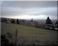
When the photograph was taken, this was St Andrew's Church. Now that St Mary's-South Church has closed, St Andrew's is the only Church of Scotland church in Blairgowrie and hence is the parish church. The field in the foreground is at the top of Newton Street and, before climate change, was much in use in snowy weather as a sledging field, due to its slope. It will probably soon be built over, as are most green spaces in the town.
Image: © Nora Brown
Taken: 10 Nov 2002
0.07 miles
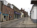
10
Telephone exchange, Blairgowrie
Located on the junction of Upper Allan Street and James Street, the rather scruffy looking building provides telephone connections to some 4,500 premises in the local area.
Image: © Richard Dorrell
Taken: 24 Feb 2013
0.07 miles