
IMAGES TAKEN NEAR TO
Bartlett Drive, PETERBOROUGH, PE2 9FN
Introduction
This page details the photographs taken nearby to Bartlett Drive, PE2 9FN by members of the Geograph project.
The Geograph project started in 2005 with the aim of publishing, organising and preserving representative images for every square kilometre of Great Britain, Ireland and the Isle of Man.

There are currently over 7.5m images from over14,400 individuals and you can help contribute to the project by visiting https://www.geograph.org.uk
Image Map
Images are licensed for reuse under creativecommons.org/licenses/by-sa/2.0
Notes
- Clicking on the map will re-center to the selected point.
- The higher the marker number, the further away the image location is from the centre of the postcode.
Image Listing (34 Images Found)
Images are licensed for reuse under creativecommons.org/licenses/by-sa/2.0
Image
Details
Distance


3
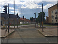
Looking west to Drake Avenue across London Road, Peterborough
A big storm cloud is developing further west.
Image: © Robin Stott
Taken: 25 Jun 2016
0.05 miles

6
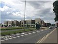
Local shops being built between London Road and Drake Avenue, Peterborough
Image: © Robin Stott
Taken: 25 Jun 2016
0.08 miles

8

Work in progress, Old Fletton
The next phase of a housing development on a brown field site. This particular area was part of the huge lorry park and maintenance garage for London Brick delivery lorries.
Image: © Michael Trolove
Taken: 13 Sep 2009
0.09 miles
9
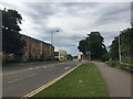
North on London Road near Hicks Lane, Peterborough
A local shopping centre is under construction, centre. Catching the sun is a block of low-rise flats at the corner of Cook Avenue.
Image: © Robin Stott
Taken: 25 Jun 2016
0.10 miles
10

South on London Road near Hicks Lane, Peterborough
The A1139 dual carriageway, the city's southern and eastern ring road, crosses the London Road ahead. On the left, Hudson Grove. The viewpoint is just past the junction with Drake Avenue.
Image: © Robin Stott
Taken: 25 Jun 2016
0.10 miles