IMAGES TAKEN NEAR TO
Wastwater, HUNTINGDON, PE29 6UP
Introduction
This page details the photographs taken nearby to Wastwater, PE29 6UP by members of the Geograph project.
The Geograph project started in 2005 with the aim of publishing, organising and preserving representative images for every square kilometre of Great Britain, Ireland and the Isle of Man.

There are currently over 7.5m images from over14,400 individuals and you can help contribute to the project by visiting https://www.geograph.org.uk
Image Map
Images are licensed for reuse under creativecommons.org/licenses/by-sa/2.0
Notes
- Clicking on the map will re-center to the selected point.
- The higher the marker number, the further away the image location is from the centre of the postcode.
Image Listing (12 Images Found)
Images are licensed for reuse under creativecommons.org/licenses/by-sa/2.0
Image
Details
Distance
1
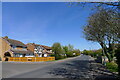
Wertheim Way, Huntingdon
Named after Wertheim am Main, in Germany, with which Huntingdon is 'twinned'.
Image: © Tim Heaton
Taken: 23 Apr 2021
0.11 miles
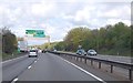
3
Westbound A14 Nearing Spittals Junction (J23)
Image: © David Dixon
Taken: 5 Aug 2013
0.20 miles
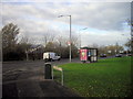
4
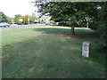
Old Milestone
Old milestone at Huntingdon, Cambridgeshire. For closeup view see http://www.geograph.org.uk/photo/1484826
Image: © Keith Evans
Taken: 11 Sep 2009
0.21 miles
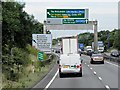
6

Closed Refuge Area, Eastbound A14 near Huntingdon
Image: © David Dixon
Taken: 1 Aug 2013
0.22 miles
7
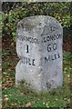
Old Milestone by the B1044, Stukeley Road, Huntingdon parish
Carved stone post by the B1043, in parish of HUNTINGDON (HUNTINGDONSHIRE District), Stukeley Road. Re-located to North side of road, on wide grass verge behind bus shelter, by "Dunelm" store, near junction with St Margarets Way. Huntingdon stone, erected by the Royston to Wandesford Bridge (South District) turnpike trust in the 19th century.
Inscription reads:-
: TO / HUNTINGDON / 1 / MILE : : TO / LONDON / 60 / MILES :
Milestone Society National ID: HU_LYA60.
Image: © MW Hallett
Taken: 9 Apr 2007
0.22 miles
8
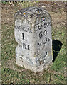
Old Milestone by the B1044, Stukeley Road, Huntingdon parish
Carved stone post by the B1043, in parish of HUNTINGDON (HUNTINGDONSHIRE District), Stukeley Road. Re-located to North side of road, on wide grass verge behind bus shelter, by "Dunelm" store, near junction with St Margarets Way. Huntingdon stone, erected by the Royston to Wandesford Bridge (South District) turnpike trust in the 19th century.
Inscription reads:-
: TO / HUNTINGDON / 1 / MILE : : TO / LONDON / 60 / MILES :
Milestone Society National ID: HU_LYA60.
Image: © Mark Brotherton
Taken: 7 Jul 2022
0.22 miles