IMAGES TAKEN NEAR TO
Longview Terrace, BOSTON, PE21 8FH
Introduction
This page details the photographs taken nearby to Longview Terrace, PE21 8FH by members of the Geograph project.
The Geograph project started in 2005 with the aim of publishing, organising and preserving representative images for every square kilometre of Great Britain, Ireland and the Isle of Man.

There are currently over 7.5m images from over14,400 individuals and you can help contribute to the project by visiting https://www.geograph.org.uk
Image Map
Images are licensed for reuse under creativecommons.org/licenses/by-sa/2.0
Notes
- Clicking on the map will re-center to the selected point.
- The higher the marker number, the further away the image location is from the centre of the postcode.
Image Listing (273 Images Found)
Images are licensed for reuse under creativecommons.org/licenses/by-sa/2.0
Image
Details
Distance
1
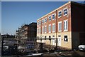
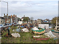
New homes on hold
Housing development off London Road, seemingly on hold with the economic downturn of early 2009
Image: © Richard Croft
Taken: 3 Feb 2009
0.01 miles
2
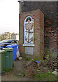
Former pub sign, London Road
A most unusual cast iron sign, Rescued from the Crown and Anchor tavern which stood on the site and was demolished in 1968, it was re-erected here in 1970. The panel below refers to George Bass, surgeon and navigator, who discovered the eponymous Bass Strait between Australia and Tasmania, at one time resident at the tavern. The panel is Listed Grade II.
Image: © Alan Murray-Rust
Taken: 19 Nov 2014
0.03 miles
3
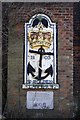
The site of the Crown & Anchor
Cast Iron plaque in a brick surround attached to the wall of number 21 London Road. Formerly attached to the wall of the Crown & Anchor Tavern established in 1803, demolished in 1968 and relocated here in 1970. The plaque below reads ....
The site of the Crown & Anchor Tavern, possibly known as the Rope & Anchor Tavern, was the home of George Bass, surgeon and navigator (1774-1803) who discovered Bass Strait and played a significant part in the history of Tasmania and Victoria, Australia
Image: © Richard Croft
Taken: 3 Feb 2009
0.03 miles
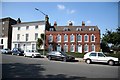
4
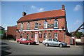
The Ship Inn
Wharfside inn on London Road, first licensed in 1815
Image: © Richard Croft
Taken: 18 Sep 2008
0.03 miles
5
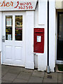
London Road Post Office postbox, ref PE21 6
A relatively uncommon EVIIR size B wall box with the later cipher. The Post Office has long since disappeared.
Image: © Alan Murray-Rust
Taken: 19 Nov 2014
0.03 miles
6
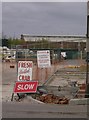
Slow Crabs?
How would you like your crab boiled sir? Slow, please.
Image: © Graham Horn
Taken: 20 Apr 2007
0.03 miles
8
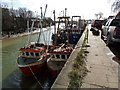
The Haven, Boston
Looking down river at the 10 metre boats tied up at the Mussel Stage.
Image: © Dave Hitchborne
Taken: 26 Feb 2008
0.04 miles
9
Wharf alongside London Road
Still a busy fishing wharf serving the mussel fisheries in the Wash.
Image: © Alan Murray-Rust
Taken: 19 Nov 2014
0.04 miles
10
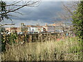
Georgian houses on London Road
London Road is now bypassed but the architecture illustrates its former importance, these three early 18th century houses sit between wharfside warehouses.
Image: © Richard Croft
Taken: 18 Sep 2008
0.04 miles