IMAGES TAKEN NEAR TO
Chapel Court, SPALDING, PE12 9TN
Introduction
This page details the photographs taken nearby to Chapel Court, PE12 9TN by members of the Geograph project.
The Geograph project started in 2005 with the aim of publishing, organising and preserving representative images for every square kilometre of Great Britain, Ireland and the Isle of Man.

There are currently over 7.5m images from over14,400 individuals and you can help contribute to the project by visiting https://www.geograph.org.uk
Image Map
Images are licensed for reuse under creativecommons.org/licenses/by-sa/2.0
Notes
- Clicking on the map will re-center to the selected point.
- The higher the marker number, the further away the image location is from the centre of the postcode.
Image Listing (13 Images Found)
Images are licensed for reuse under creativecommons.org/licenses/by-sa/2.0
Image
Details
Distance
1
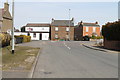
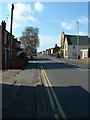
Junction of Railway Lane and Bridge Road
Image: © J.Hannan-Briggs
Taken: 7 Apr 2013
0.07 miles
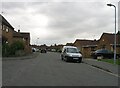
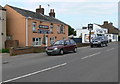
3
Bridge Road, Sutton Bridge
The main street through the village. It was the main A17 until the Washway bypass was built in the 1980s. The village dates mostly from the 1830s when a new cut was built to drain Cross Keys Marsh, and was bridged at this point.
Image: © David Prestidge
Taken: 17 Mar 2007
0.09 miles
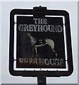
4
The Greyhound public house
On Bridge Road in Sutton Bridge.
Image: © Mat Fascione
Taken: 1 Jun 2013
0.09 miles
5
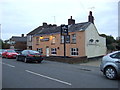
The Greyhound, Sutton Bridge
On Bridge Road.
Image: © JThomas
Taken: 23 Oct 2015
0.09 miles
6
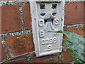
Ordnance Survey Flush Bracket S0298
This can be found on the wall of the former school - now commercial units - at 69 Bridge Road, Sutton Bridge.
For more detail see : http://www.bench-marks.org.uk/bm11734
Image: © Peter Wood
Taken: 8 Nov 2014
0.18 miles
7
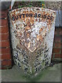
Old Milepost
Old milepost Sutton Bridge, Lincolnshire. For overall view see http://www.geograph.org.uk/photo/1186764
Image: © Keith Evans
Taken: 2 Mar 2009
0.20 miles
8
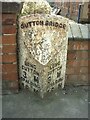
Old Milestone, B1359, Bridge Road, by No. 67
Located on the South side of road, in pavement. Cast iron post, erected by Holbeach turnpike trust, 19th century. Alternative view see http://www.geograph.org.uk/photo/1186738
Inscription reads: // LONG / SUTTON / 3M / SPALDING / 16M // LONG / SUTTON / 3M / SPALDING / 16M // SUTTON BRIDGE
Milestone Society National ID: LI_SUSB03
Image: © Milestone Society
Taken: Unknown
0.20 miles