IMAGES TAKEN NEAR TO
Daniels Crescent, SPALDING, PE12 9DS
Introduction
This page details the photographs taken nearby to Daniels Crescent, PE12 9DS by members of the Geograph project.
The Geograph project started in 2005 with the aim of publishing, organising and preserving representative images for every square kilometre of Great Britain, Ireland and the Isle of Man.

There are currently over 7.5m images from over14,400 individuals and you can help contribute to the project by visiting https://www.geograph.org.uk
Image Map
Images are licensed for reuse under creativecommons.org/licenses/by-sa/2.0
Notes
- Clicking on the map will re-center to the selected point.
- The higher the marker number, the further away the image location is from the centre of the postcode.
Image Listing (30 Images Found)
Images are licensed for reuse under creativecommons.org/licenses/by-sa/2.0
Image
Details
Distance
1
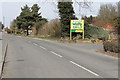
Butterfly and Wildlife Park, Long Sutton
Entrance to the Park. http://www.butterflyandwildlifepark.co.uk/index.html
Image: © Ian Paterson
Taken: 3 Nov 2007
0.09 miles
4
Allotments on Daniel's Gate, Long Sutton
Image: © Richard Humphrey
Taken: 7 Dec 2011
0.13 miles
5
Entrance to Butterfly & Wildlife Park, Long Sutton
The sign says "The Park is now closed - Thank You for your custom". Closed permanently apparently.
Image: © J.Hannan-Briggs
Taken: 7 Apr 2013
0.13 miles
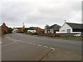
8
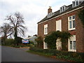
Houses on Daniel's Gate, Long Sutton
A newer part of town.
Image: © Robin Webster
Taken: 12 Feb 2018
0.14 miles
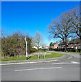
9
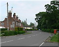
Postbox along Roman Bank
The postbox is at the junction of Roman Bank, Little London and Park Road, in the village of Long Sutton.
Image: © Mat Fascione
Taken: 1 Jun 2013
0.15 miles
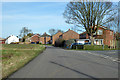
10
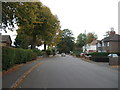
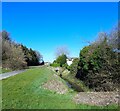
Park Road, Long Sutton
Looking north east.
Image: © JThomas
Taken: 24 Oct 2015
0.16 miles