IMAGES TAKEN NEAR TO
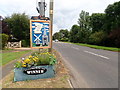
Wisbech Road, SPALDING, PE12 9AG
Introduction
This page details the photographs taken nearby to Wisbech Road, PE12 9AG by members of the Geograph project.
The Geograph project started in 2005 with the aim of publishing, organising and preserving representative images for every square kilometre of Great Britain, Ireland and the Isle of Man.

There are currently over 7.5m images from over14,400 individuals and you can help contribute to the project by visiting https://www.geograph.org.uk
Image Map
Images are licensed for reuse under creativecommons.org/licenses/by-sa/2.0
Notes
- Clicking on the map will re-center to the selected point.
- The higher the marker number, the further away the image location is from the centre of the postcode.
Image Listing (49 Images Found)
Images are licensed for reuse under creativecommons.org/licenses/by-sa/2.0
Image
Details
Distance
1
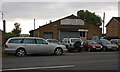
Windmill Garage
A small car dealership on the Wisbech Road outside Long Sutton. Seemes to be a multi-skilled trader, which is probably necessary to survive in the countryside rather than the city.
Image: © Martin Addison
Taken: 6 Aug 2008
0.05 miles
2
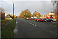
Wisbech Road, Long Sutton
Looking towards the village centre.
Image: © Kate Jewell
Taken: 23 Nov 2007
0.06 miles
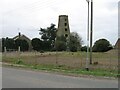

8
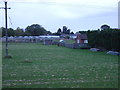
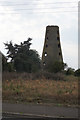
Grazing near Long Sutton
View towards Brunswick Mill.
Image: © JThomas
Taken: 24 Oct 2015
0.08 miles
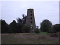
9

Long Sutton, Brunswick (derelict) windmill
Conserved for posterity.
Image: © Adrian S Pye
Taken: 6 Jan 2011
0.09 miles
10
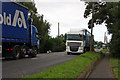
Wisbech Road
Trucks pass on the B1359. The A17 roundabout is visible in the distance.
Image: © Martin Addison
Taken: 6 Aug 2008
0.09 miles