IMAGES TAKEN NEAR TO
Old Ferry Road, ERSKINE, PA8 6AX
Introduction
This page details the photographs taken nearby to Old Ferry Road, PA8 6AX by members of the Geograph project.
The Geograph project started in 2005 with the aim of publishing, organising and preserving representative images for every square kilometre of Great Britain, Ireland and the Isle of Man.

There are currently over 7.5m images from over14,400 individuals and you can help contribute to the project by visiting https://www.geograph.org.uk
Image Map
Images are licensed for reuse under creativecommons.org/licenses/by-sa/2.0
Notes
- Clicking on the map will re-center to the selected point.
- The higher the marker number, the further away the image location is from the centre of the postcode.
Image Listing (66 Images Found)
Images are licensed for reuse under creativecommons.org/licenses/by-sa/2.0
Image
Details
Distance
1
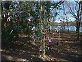
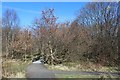
Wishing tree, Boden Boo
Not far away, on the right, is a path. The Clyde can be seen in the background.
For similar examples on the other side of the Clyde, see Image / Image / Image (Strathleven Walk).
Image: © Lairich Rig
Taken: 27 Mar 2017
0.03 miles
2
Path beside Erskine Harbour
I use the name Erskine Harbour in the title because it is employed in current and recent OS mapping; however, I am not convinced that the nearby enclosed feature on the shore was ever a harbour, although it does superficially resemble one on the map. See Image for further comments.
Image: © Lairich Rig
Taken: 27 Mar 2017
0.05 miles
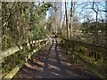
4
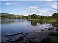
Erskine Harbour
A small inlet from the River Clyde near the former Erskine Ferry slipway. An interesting site for ornithologists and a pleasant site to relax for a while.
Image: © James T M Towill
Taken: 6 Aug 2009
0.05 miles
5
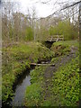
Stream Near Erskine Harbour - Downstream View
A view of this small stream, together with a footbridge carrying a path around the remains of the harbour.
Image: © James T M Towill
Taken: 10 Apr 2012
0.06 miles
7
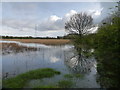
Erskine Harbour
A view of the reed-fringed remains of the harbour during a spring high tide. The Erskine Bridge Hotel can be seen through the trees.
Image: © James T M Towill
Taken: 10 Apr 2012
0.06 miles
8
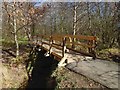
Footbridge over a burn
The 1:25000 map shows the burn that is crossed here. The footbridge is shown from a little further away in Image The origins of the burn are described at Image
Image: © Lairich Rig
Taken: 27 Mar 2017
0.06 miles
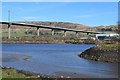
9

Gates at abandoned Erskine Ferry slipway
View towards Erskine Bridge
Image: © Leslie Barrie
Taken: 24 Mar 2014
0.07 miles
10
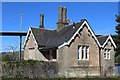
Ferry Lodge, Erskine
Stands by the slipway of the former Erskine Ferry. The Erskine Bridge can be seen behind.
Image: © Leslie Barrie
Taken: 24 Mar 2014
0.07 miles