IMAGES TAKEN NEAR TO
Drimnin, OBAN, PA80 5XZ
Introduction
This page details the photographs taken nearby to PA80 5XZ by members of the Geograph project.
The Geograph project started in 2005 with the aim of publishing, organising and preserving representative images for every square kilometre of Great Britain, Ireland and the Isle of Man.

There are currently over 7.5m images from over14,400 individuals and you can help contribute to the project by visiting https://www.geograph.org.uk
Image Map
Images are licensed for reuse under creativecommons.org/licenses/by-sa/2.0
Notes
- Clicking on the map will re-center to the selected point.
- The higher the marker number, the further away the image location is from the centre of the postcode.
Image Listing (5 Images Found)
Images are licensed for reuse under creativecommons.org/licenses/by-sa/2.0
Image
Details
Distance
1
Farm in Morvern
This is taken from a higher spot in this square looking onto the house near Druim na Cracaig. In the near distance is the North tip of Mull, Tobermory and the hills of Ardnamurchan.
Image: © Kathy E
Taken: 3 Sep 2005
0.09 miles
4

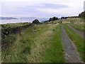
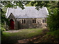
B849 and track to a church near Drimnin
Image: © Steven Brown
Taken: 28 Jun 2014
0.18 miles
5
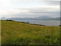
Grazing grassland with view to Mull and a CalMac Ferry.
This square consists of coastline with deciduous woodland (visible at the foot of the hill) and a steepish grassy hill that is used for grazing. The Ferry is the Caledonian MacBrayne service from South Uist to Oban. Mull is visible beyond.
Image: © Kathy E
Taken: 3 Sep 2005
0.22 miles