IMAGES TAKEN NEAR TO
Erskine Ferry Road, BISHOPTON, PA7 5PP
Introduction
This page details the photographs taken nearby to Erskine Ferry Road, PA7 5PP by members of the Geograph project.
The Geograph project started in 2005 with the aim of publishing, organising and preserving representative images for every square kilometre of Great Britain, Ireland and the Isle of Man.

There are currently over 7.5m images from over14,400 individuals and you can help contribute to the project by visiting https://www.geograph.org.uk
Image Map
Images are licensed for reuse under creativecommons.org/licenses/by-sa/2.0
Notes
- Clicking on the map will re-center to the selected point.
- The higher the marker number, the further away the image location is from the centre of the postcode.
Image Listing (50 Images Found)
Images are licensed for reuse under creativecommons.org/licenses/by-sa/2.0
Image
Details
Distance
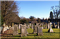
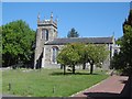
2
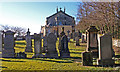
Bishopton Parish Church
Some way outside of Bishopton on Ferry Road.
Image: © Thomas Nugent
Taken: 7 Aug 2010
0.08 miles
3

Bishopton Parish Church Graveyard
On the back of this headstone a skull and crossbones. A very old stone and the front was impossible to read.
Image: © wfmillar
Taken: 1 Mar 2010
0.08 miles
4
Bishopton Parish Church Graveyard
Elaborate headstone in the yard.
Image: © wfmillar
Taken: 1 Mar 2010
0.09 miles
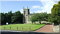
6
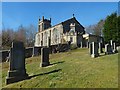
Bishopton Parish Church Graveyard
In this view you can see the modern extension.
Image: © wfmillar
Taken: 1 Mar 2010
0.09 miles
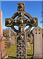
7
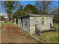
The Sempill Enclosure
The structure is near the centre of the kirkyard of Image On its near side, it bears the worn inscription "Restored by Maria Baroness Sempill MDCCCLIII", and the Sempill arms.
The sun's illumination was at a favourable angle when I visited, but, without that, the worn inscription is hard to read, as exemplified by the published(*) pre-1855 MI records, which give "Mabel" as the name. However, "Maria" is the correct reading, as confirmed both by my close examination of the stone, and by independent sources.
[(*) My comments above refer specifically to the Monumental Inscriptions records published in 1992; revised editions may have been issued since then.]
The person named in that inscription is Lady Maria-Janet Sempill, born in 1790, daughter of Hugh, 14th Lord Sempill. She succeeded her brother Selkirk in 1835, becoming 16th Lady Sempill. She married in the following year, and died without issue in 1884.
The first Lord Sempill was Sir John Sempill of Eliestoun, who was created Lord Sempill in c.1488. A detailed genealogy can be found in Crawfurd's "General Description of the Shire of Renfrew", and in Robertson's continuation of that work.
The former site of a church, as marked on early OS maps, was just to the north-east of this enclosure, or, in terms of the present photograph, just behind the enclosure.
Image: © Lairich Rig
Taken: 27 Mar 2017
0.10 miles
8
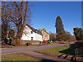
Ailsa Lodge Care Home
Beside the B815 near Bishopton Parish Church.
Image: © wfmillar
Taken: 1 Mar 2010
0.10 miles
9
Kirkyard of Old Erskine Parish Church
The vestry mentioned in the end-note can be seen in the present picture, as an addition to the near end of Image (the old Erskine Parish Church).
Image: © Lairich Rig
Taken: 27 Mar 2017
0.10 miles
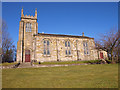
10
Bishopton Parish Church
The church is some distance to the modern settlement of Bishopton.
Image: © Richard Webb
Taken: 2 Jun 2016
0.10 miles