IMAGES TAKEN NEAR TO
Ardlussa, ISLE OF JURA, PA60 7XL
Introduction
This page details the photographs taken nearby to PA60 7XL by members of the Geograph project.
The Geograph project started in 2005 with the aim of publishing, organising and preserving representative images for every square kilometre of Great Britain, Ireland and the Isle of Man.

There are currently over 7.5m images from over14,400 individuals and you can help contribute to the project by visiting https://www.geograph.org.uk
Image Map (Loading...)


Getting Data...Please wait
Leaflet Map data © OpenStreetMap
Images are licensed for reuse under creativecommons.org/licenses/by-sa/2.0
Notes
- Clicking on the map will re-center to the selected point.
- The higher the marker number, the further away the image location is from the centre of the postcode.
Image Listing (28 Images Found)
Images are licensed for reuse under creativecommons.org/licenses/by-sa/2.0
Image
Details
Distance
1
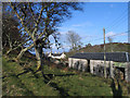
Buildings at Ardlussa
Farm buildings and more distantly, cottages at the small Jura settlement of Ardlussa are seen from the track rising northwards for the low hill Cnoc an Lomair.
Image: © Trevor Littlewood
Taken: 17 Apr 2006
0.03 miles
2

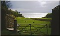
View from road at Ardlussa Bay
Looking along the field margin towards the large house at Ardlussa.
Image: © Nick Smith
Taken: 11 Apr 2006
0.04 miles
3

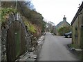
House and separate cottage on road to Ardlussa bay.
The small cottage may once have been a schoolhouse.
Image: © Nick Smith
Taken: 11 Apr 2006
0.05 miles
4
Fresh pasture at Ardlussa
Kintyre across the sea.
Image: © Alan Reid
Taken: 21 May 1996
0.06 miles
5
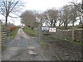
The Jura Road, Ardlussa
The one long road, passing through estate buildings, including a subterranean one on the left, which may have been an ice house. The big house is out of sight to the right. The woods and fields of the policies are a big contrast to the endless moorgrass of the wild interior of the island.
Image: © Richard Webb
Taken: 10 Apr 2008
0.07 miles
6
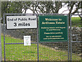
Not the end of the road, Ardlussa
A useful sign as this looks like the end of the public road. End of the bus service though.
Image: © Richard Webb
Taken: 10 Apr 2008
0.08 miles
7
Entrance to the Ardlussa Estate
These signs are situated at the side of the road as it enters Ardlussa. The sign on the right has been replaced recently - see http://www.geograph.org.uk/photo/767259 taken in 2008.
Image: © Bob Jones
Taken: 11 Jun 2011
0.09 miles
8
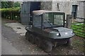
All terrain vehicle
The all terrain vehicle that is used to bring the shot stags and hinds off the hills.
Image: © Alan Gerrard
Taken: 5 Sep 2008
0.10 miles
9
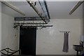
Inside deer preparation room 2
Inside the building where the shot stags and hinds are prepared. Note all the paraphernalia needed to complete the task, saw, hooks, scales, hose pipe etc.
Image: © Alan Gerrard
Taken: 5 Sep 2008
0.10 miles
10
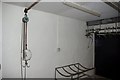
Inside deer preparation room 1
Inside the building where the shot stags and hinds are prepared. Note all the paraphernalia needed to complete the task, saw, hooks, scales, hose pipe etc.
Image: © Alan Gerrard
Taken: 5 Sep 2008
0.10 miles