IMAGES TAKEN NEAR TO
Newton Avenue, JOHNSTONE, PA5 9BE
Introduction
This page details the photographs taken nearby to Newton Avenue, PA5 9BE by members of the Geograph project.
The Geograph project started in 2005 with the aim of publishing, organising and preserving representative images for every square kilometre of Great Britain, Ireland and the Isle of Man.

There are currently over 7.5m images from over14,400 individuals and you can help contribute to the project by visiting https://www.geograph.org.uk
Image Map
Images are licensed for reuse under creativecommons.org/licenses/by-sa/2.0
Notes
- Clicking on the map will re-center to the selected point.
- The higher the marker number, the further away the image location is from the centre of the postcode.
Image Listing (34 Images Found)
Images are licensed for reuse under creativecommons.org/licenses/by-sa/2.0
Image
Details
Distance
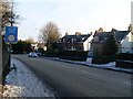
1
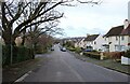
Newton Avenue
Quiet residential street.
Image: © Richard Sutcliffe
Taken: 1 Mar 2024
0.04 miles
2
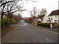
Newton Avenue Elderslie
Looking towards the B789 Main Road Elderslie.
Image: © Gordon Dowie
Taken: 23 Apr 2010
0.09 miles
3
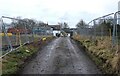
Newton Cottage
Cottage at the very end of Newton Avenue. The area to both sides of the road have been cleared of trees in advance of house building.
Image: © Richard Sutcliffe
Taken: 1 Mar 2024
0.11 miles
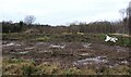
4
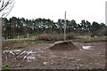
Cleared site
Trees have been cleared here in advance of building new houses.
Image: © Richard Sutcliffe
Taken: 1 Mar 2024
0.11 miles
5
Disused railway bridge, Elderslie
Carried the old Paisley Canal line. Now carries the National Cycle Path routes 7 and 75.
Image: © Stephen Sweeney
Taken: 3 Jan 2010
0.12 miles
6
Cleared site
Trees have been cleared here in advance of building new houses.
Image: © Richard Sutcliffe
Taken: 1 Mar 2024
0.13 miles
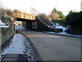
7
Approaching the low disused railway bridge over Elderslie Main Road
From the west.
Image: © Stephen Sweeney
Taken: 3 Jan 2010
0.13 miles
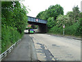
8
B789 approaching disused railway bridge
Just west of roundabout with A761
Image: © John Firth
Taken: 13 May 2012
0.14 miles
9
Main Road
Leading from paisley to Elderslie. The bridge carried the former Paisley Canal line and is now a cycle path (Route 7 of the National Cycle Network).
Image: © Thomas Nugent
Taken: 14 Jun 2013
0.14 miles
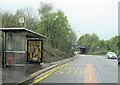
10
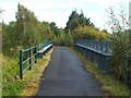
Cycle route at Elderslie
At this point, the cycle route (NCN7 and NCN75), which follows the former course of a railway line, is carried above the main road by means of the bridge that is shown in Image
Image: © Lairich Rig
Taken: 7 Oct 2010
0.14 miles