IMAGES TAKEN NEAR TO
Hawthorn Avenue, JOHNSTONE, PA5 0EA
Introduction
This page details the photographs taken nearby to Hawthorn Avenue, PA5 0EA by members of the Geograph project.
The Geograph project started in 2005 with the aim of publishing, organising and preserving representative images for every square kilometre of Great Britain, Ireland and the Isle of Man.

There are currently over 7.5m images from over14,400 individuals and you can help contribute to the project by visiting https://www.geograph.org.uk
Image Map
Images are licensed for reuse under creativecommons.org/licenses/by-sa/2.0
Notes
- Clicking on the map will re-center to the selected point.
- The higher the marker number, the further away the image location is from the centre of the postcode.
Image Listing (32 Images Found)
Images are licensed for reuse under creativecommons.org/licenses/by-sa/2.0
Image
Details
Distance
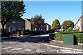
1

Junction of Willow Drive and Hawthorn Avenue, Johnstone
March 1st 2018 - 'The Beast from the East'
Image: © Vince Madden
Taken: 1 Mar 2018
0.04 miles
3
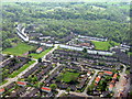
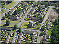
Housing estate, Johnstone
The southern edge of the town - a series of streets with a tree-name theme, and Craigston Wood beyond.
Image: © M J Richardson
Taken: 11 May 2016
0.06 miles
4
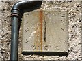
Sundial on Johnstone Castle
The setting is rather spoiled by the adjacent pipe (whose run-off has also stained it), but this sundial, dated 1700, is still of interest. It is fixed high on the south-facing wall of Image Its location can be picked out, on the right, in Image
This is a vertical direct south dial (see Image), but it has lost its gnomon.
Image: © Lairich Rig
Taken: 11 Jul 2011
0.11 miles
5
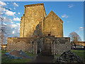
Johnstone Castle
South elevation showing some of the seemingly abandoned building works.
Image: © wfmillar
Taken: 3 Feb 2009
0.11 miles
6
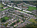
Johnstone Castle from the air
This area of Johnstone takes its name from the nearby Johnstone Castle Image Major redevelopment appears to be in progress.
Image: © Thomas Nugent
Taken: 4 Oct 2019
0.11 miles
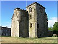
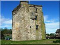
7
Johnstone Castle from the air
A castle in the middle of a housing scheme on the outskirts of Johnstone. Category B Listed http://portal.historicenvironment.scot/designation/LB35602 , described as follows on Canmore https://canmore.org.uk/site/43213/johnstone-castle ...
""Johnstoun, an old possession of the Nisbets, came from them to the Wallaces, continued six generations a house of good account, now decayed".
W Macfarlane 1907
Johnstone Castle, now situated in a modern housing scheme, was originally named "Easter Cochran" and owned by the family of that ilk, its name changed in 1733 when it was acquired by the Houstons of Johnstone. they added to and altered the former mainly 16th century fortalice in the years that followed. Now that the estate has been taken over by the burgh, most of the extended mansion has been pulled down and only the original part is left, though much scarred by 19th century 'improvements'. It is now used as a store.
The castle as it now stands is L-shaped and consists of a comparatively little-altered main block of three storyes and a garret, lying E-W, with a wing, now built in the form of a massive Gothic tower, projecting N and rising a storey higher. Apart from two tiny windows at basement level, and others built up, the wing has been very much altered.
The hall, on the first floor of the main block, has also been much altered, but still retains a garderobe and a very deep window embrasure, giving the impression of a nucleus older than the 16th century.
N Tranter 1970."
Image: © Thomas Nugent
Taken: 28 Jun 2019
0.12 miles
9

Johnstone Castle
For several earlier photos of the castle, giving views from different angles, see http://www.geograph.org.uk/photo/927914 / http://www.geograph.org.uk/photo/1146410 / http://www.geograph.org.uk/photo/1146428 / http://www.geograph.org.uk/photo/1146443 / http://www.geograph.org.uk/photo/1146458
In the present view, Hawthorn Avenue is in front of the castle, and Tower Road is behind it. One feature that caught my attention was a Image
To complement the material in the WoSAS link (see the end-note), it is probably worth commenting on the site in relation to what is shown on old maps. Modern Johnstone is east of the Black Cart Water, but the Blaeu map of Renfrew (c.1654, but based on considerably earlier surveys) shows Johnstone ("Ihonstoun") on the western side of the river.
In 1733, the Houstouns, owners of the Johnstone estate (then west of the river), relocated; their old estate was renamed Milliken, but the Houstouns took their title (Johnstone) with them to their new lands, east of the river, in what had been the Cochran estate ("Cochern" appears on the Blaeu map).
On that side, Roy's Military Survey (1740s-50s) shows "Cochran Castle": not the building that is shown in this photo, but a quite different structure which was located some distance to the WSW, at c.Image; see https://canmore.org.uk/site/43232/johnstone-red-house-cochrane-tower (at Canmore) for details.
The present-day Johnstone Castle, shown in my photograph, stands in an area that was called Quarreltoun on the Blaeu map, and Quarrelton on Roy's map.
Ainslie's map of 1796 shows a building (presumably Cochran Castle) near the words "Cochran Place". To the ENE, another building is located at Johnston Place, just south of Quarrelton; it is presumably the tower shown in the present photograph.
Image: © Lairich Rig
Taken: 11 Jul 2011
0.12 miles