Johnstone Castle
Introduction
The photograph on this page of Johnstone Castle by Lairich Rig as part of the Geograph project.
The Geograph project started in 2005 with the aim of publishing, organising and preserving representative images for every square kilometre of Great Britain, Ireland and the Isle of Man.

There are currently over 7.5m images from over 14,400 individuals and you can help contribute to the project by visiting https://www.geograph.org.uk
Johnstone Castle
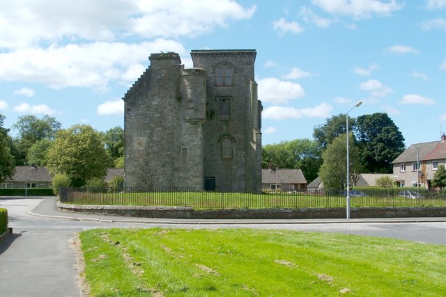
Image: © Lairich Rig Taken: 11 Jul 2011
For several earlier photos of the castle, giving views from different angles, see http://www.geograph.org.uk/photo/927914 / http://www.geograph.org.uk/photo/1146410 / http://www.geograph.org.uk/photo/1146428 / http://www.geograph.org.uk/photo/1146443 / http://www.geograph.org.uk/photo/1146458 In the present view, Hawthorn Avenue is in front of the castle, and Tower Road is behind it. One feature that caught my attention was a Image To complement the material in the WoSAS link (see the end-note), it is probably worth commenting on the site in relation to what is shown on old maps. Modern Johnstone is east of the Black Cart Water, but the Blaeu map of Renfrew (c.1654, but based on considerably earlier surveys) shows Johnstone ("Ihonstoun") on the western side of the river. In 1733, the Houstouns, owners of the Johnstone estate (then west of the river), relocated; their old estate was renamed Milliken, but the Houstouns took their title (Johnstone) with them to their new lands, east of the river, in what had been the Cochran estate ("Cochern" appears on the Blaeu map). On that side, Roy's Military Survey (1740s-50s) shows "Cochran Castle": not the building that is shown in this photo, but a quite different structure which was located some distance to the WSW, at c.Image; see https://canmore.org.uk/site/43232/johnstone-red-house-cochrane-tower (at Canmore) for details. The present-day Johnstone Castle, shown in my photograph, stands in an area that was called Quarreltoun on the Blaeu map, and Quarrelton on Roy's map. Ainslie's map of 1796 shows a building (presumably Cochran Castle) near the words "Cochran Place". To the ENE, another building is located at Johnston Place, just south of Quarrelton; it is presumably the tower shown in the present photograph.
Images are licensed for reuse under creativecommons.org/licenses/by-sa/2.0
Image Location
Latitude
55.827884
Longitude
-4.50767