IMAGES TAKEN NEAR TO
Ferry Road, RENFREW, PA4 8SH
Introduction
This page details the photographs taken nearby to Ferry Road, PA4 8SH by members of the Geograph project.
The Geograph project started in 2005 with the aim of publishing, organising and preserving representative images for every square kilometre of Great Britain, Ireland and the Isle of Man.

There are currently over 7.5m images from over14,400 individuals and you can help contribute to the project by visiting https://www.geograph.org.uk
Image Map
Images are licensed for reuse under creativecommons.org/licenses/by-sa/2.0
Notes
- Clicking on the map will re-center to the selected point.
- The higher the marker number, the further away the image location is from the centre of the postcode.
Image Listing (196 Images Found)
Images are licensed for reuse under creativecommons.org/licenses/by-sa/2.0
Image
Details
Distance
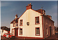
1
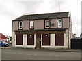
Disused Building, Renfrew
Former Barton's Bakery, this premises may well be worth a pound or two, especially on completion of the nearby Ferry Village.
Image: © Stephen Sweeney
Taken: 20 Jun 2007
0.01 miles
2
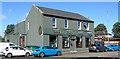
Green Gates Indian restaurant
On Ferry Road, near Renfrew Ferry.
Image: © Thomas Nugent
Taken: 20 Aug 2022
0.03 miles
3
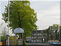
Welcome to Renfrewshire
Ferry Road [A741], leading from the Renfrew-Yoker pedestrian ferry terminal.
Image: © M J Richardson
Taken: 2 May 2012
0.03 miles
4
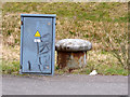
Old bollard on Ferry Road
The bollard is now remote from Ferry Dock which was partially filled as part of the North Renfrew Flood Prevention Scheme.
Image: © Thomas Nugent
Taken: 31 Mar 2018
0.04 miles
5
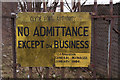
Old sign
The Clyde Port Authority building is long gone Image, but this sign survives, at least for a few more months as redevelopment of the site is underway. See also Image
Image: © Thomas Nugent
Taken: 29 Mar 2010
0.04 miles
6
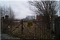
Former Clyde Port Authority site
At Ferry Dock, by the Renfrew Ferry. See the yellow sign here Image
Image: © Thomas Nugent
Taken: 29 Mar 2010
0.04 miles
7
North Renfrew Flood Prevention Scheme
The pumping station is to the left of the concrete wall, which is closeable a gap in the defences to enable Ferry Road to operate normally during non flood conditions.
Image: © Thomas Nugent
Taken: 31 Mar 2018
0.04 miles
8
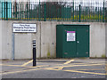
Ferry Road emergency flood barrier
The pumping station of the North Renfrew Flood Prevention Scheme is behind the railings. The scheme aims to ensure that the area will have a 1 in 200 year level of flood protection from the combined risks of the Mill Burn overflowing and tidal surges from the River Clyde.
Image: © Thomas Nugent
Taken: 31 Mar 2018
0.05 miles
9
Ferry Inn, Renfrew
The pub was run by the same family for around 150 years, until the council cancelled the lease in the late 1990s.
Image: © David Douglas
Taken: Unknown
0.05 miles
10
Sign at the Renfrew Ferry
Small passenger ferry that runs daily between Renfrew and Yoker.
Image: © Stephen Sweeney
Taken: 26 Aug 2008
0.05 miles