IMAGES TAKEN NEAR TO
Nethergreen Wynd, RENFREW, PA4 8HS
Introduction
This page details the photographs taken nearby to Nethergreen Wynd, PA4 8HS by members of the Geograph project.
The Geograph project started in 2005 with the aim of publishing, organising and preserving representative images for every square kilometre of Great Britain, Ireland and the Isle of Man.

There are currently over 7.5m images from over14,400 individuals and you can help contribute to the project by visiting https://www.geograph.org.uk
Image Map
Images are licensed for reuse under creativecommons.org/licenses/by-sa/2.0
Notes
- Clicking on the map will re-center to the selected point.
- The higher the marker number, the further away the image location is from the centre of the postcode.
Image Listing (32 Images Found)
Images are licensed for reuse under creativecommons.org/licenses/by-sa/2.0
Image
Details
Distance
1
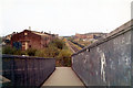
Railway footbridge, Moorpark / Kirklandneuk, 1977
Tracks used by factory until mid 1970s. Removed in 1978.
Image: © David Douglas
Taken: Unknown
0.04 miles
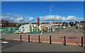
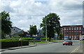
2
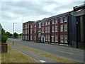
Westway Gatehouse Offices
Earlier usage is indicated by an inscription at the top of the marble doorway on this side of the building: "Babcock and Wilcox 1907". Compare Image, located not far away in the same industrial park.
Porterfield Road is in the foreground. For a view around the corner of the building, see Image (compare Image). For the building of which a small part appears at the far right of the present picture, see Image
Image: © Lairich Rig
Taken: 7 Jul 2018
0.12 miles
3
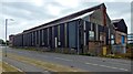
Works beside Porterfield Road
The works are attached to the Image, which are visible at the far left.
Image: © Lairich Rig
Taken: 7 Jul 2018
0.13 miles
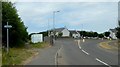
4
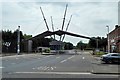
The entrance to Westway Park
Westway Park is a large industrial park in Renfrew. The view is from Porterfield Road (running L—R in foreground). On the right are the Image; see Image for more context.
The booth under the spiky canopy stands near the earlier site of a railway station: Porterfield Station, for which see https://canmore.org.uk/site/197680 at Canmore. The course of the railway lines corresponds closely to that of the present-day road that leads past the booth.
Porterfield Road takes its name from Porterfield, which stood at Image: "this farm steading is the property of the burgh of Renfrew; now occupied by John Muir" (OS Name Books, c.1857). In 1856, a road, corresponding to the line of present-day Porterfield Road, already led ESE from there.
By 1895, industry was springing up nearby: the Albert Cabinet Works were at Image (now housing), and the Renfrew Forge & Steel Works were at Image (which is still industrial).
The 1911 map revision shows Porterfield Station, mentioned above; a rifle range (Image) just northeast of the cabinet works; and many more works alongside the White Cart Water.
The 1939 map revision shows a Rubber Works (Image) within what is now Westway Park, and two travelling cranes are shown among the works by the White Cart. They moved roughly NW—SE, one through Image, the other through Image; at the time of writing, the tracks that supported the second of these travelling cranes can still be discerned on satellite imagery.
Image: © Lairich Rig
Taken: 7 Jul 2018
0.14 miles
5
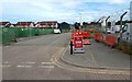
Construction of Maitland Gardens
This is a residential development beside Image
Image: © Lairich Rig
Taken: 22 Sep 2018
0.15 miles
6
Path to the White Cart Water
The sign on the left, at the start of the path, reads "Swing Bridge via White Cart Water". The "Swing Bridge" is Inchinnan Bascule Bridge. The area of housing in the right background is Kirklandneuk.
See Image and Image for views from further along the path.
Image: © Lairich Rig
Taken: 7 Jul 2018
0.15 miles
7
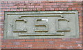
CSC stone
Above one of the doors of the former Carntyne Steel Castings building on Brown Street Image
Image: © Thomas Nugent
Taken: 23 Jun 2008
0.16 miles
8
Westway
An industrial complex on Porterfield Road.
Image: © Thomas Nugent
Taken: 4 Sep 2010
0.16 miles
9
Westway
An industrial complex at the end of Porterfield Road.
Image: © Thomas Nugent
Taken: 23 Jun 2008
0.16 miles
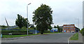
10
Brown Street North
To the left is the construction site of a housing development called Maitland Gardens: Image
Image: © Lairich Rig
Taken: 7 Jul 2018
0.17 miles