IMAGES TAKEN NEAR TO
Glencairn Road, PAISLEY, PA3 4LP
Introduction
This page details the photographs taken nearby to Glencairn Road, PA3 4LP by members of the Geograph project.
The Geograph project started in 2005 with the aim of publishing, organising and preserving representative images for every square kilometre of Great Britain, Ireland and the Isle of Man.

There are currently over 7.5m images from over14,400 individuals and you can help contribute to the project by visiting https://www.geograph.org.uk
Image Map
Images are licensed for reuse under creativecommons.org/licenses/by-sa/2.0
Notes
- Clicking on the map will re-center to the selected point.
- The higher the marker number, the further away the image location is from the centre of the postcode.
Image Listing (35 Images Found)
Images are licensed for reuse under creativecommons.org/licenses/by-sa/2.0
Image
Details
Distance
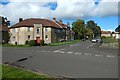
1

Glencairn Road
In the right foreground is the junction with Bargarron Drive, which continues on the other side of Glencairn Road: see Image, which, in relation to the present picture, is a view to the left from the blue sign on the grassy island in the middle of the road, left of centre.
Image: © Lairich Rig
Taken: 22 Sep 2018
0.06 miles
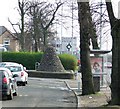
2
Bargarron Drive
It is shown here branching off from Image The view is from grassy island in the middle of that road; see the link just given.
Image: © Lairich Rig
Taken: 22 Sep 2018
0.08 miles
3

Brewster Avenue
Priory Avenue leads off to the right. Image are in the right background.
Image: © Lairich Rig
Taken: 22 Sep 2018
0.09 miles
4

Sandyford Kirk
Church of Scotland church and towerblocks, Paisley.
Image: © Richard Webb
Taken: 14 May 2006
0.12 miles
5
Cairn on Renfrew Road
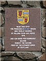
See Image] for a closer view of the cairn. A plaque on the cairn reads as follows...
Near this spot
the Princess Marjory Bruce
was fatally injured
by falling from her horse
1316
Her son, born posthumously
became
Robert The Second
first of the Stewart Kings
of Scotland
See the following more recent photos and a detailed description.
Image] Image] & Image
Image: © Thomas Nugent
Taken: 29 Mar 2007
0.13 miles
6
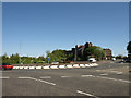
A741 Roundabout
Just at the entrance to Abbotsinch Retail Park. The dark building is an office block.
Image: © wfmillar
Taken: 13 May 2009
0.14 miles
7

Martyrs' Sandyford Church
The building is beside Image in the Gallowhill area of Paisley. The additional structure shown in an earlier picture (Image) is now gone; the blank facade on the left is evidently a remnant of it.
There is also a Image on King Street; both are descendants of an original Thread Street Church.
Background tower blocks (l-r): Image, Image, Image
Image: © Lairich Rig
Taken: 11 Jan 2014
0.15 miles
8
The Marjory Bruce Cairn
For another view, and for a much more detailed discussion, see Image
The cairn, unveiled in January 1954, stands at the junction of Dundonald Road (which is on the right) and Renfrew Road, and commemorates Marjory Bruce, daughter of King Robert the Bruce. Another contributor's earlier images show the cairn from the other side: Image / Image
For the plaque on the side facing Renfrew Road (on the left in the present picture), see Image
Image: © Lairich Rig
Taken: 7 Oct 2013
0.16 miles
9
The Marjory Bruce Cairn: plaque
For a view of the cairn as a whole, and for a much more detailed discussion of the rather doubtful tradition recorded on this plaque, see Image
For other views of the whole cairn in context, in Image, Image, and Image
Image: © Lairich Rig
Taken: 7 Oct 2013
0.16 miles
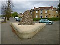
10
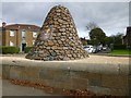
The Marjory Bruce Cairn
The cairn, which is located at the junction of Dundonald Road and Renfrew Road, commemorates Marjory Bruce, daughter of King Robert the Bruce, and mother of King Robert II. It is eight feet high, and made of whinstone, and it was unveiled in January of 1954 by a descendent of Marjory, namely Sir Guy Shaw Stewart, Baronet, Lord Lieutenant of Renfrewshire.
[Tradition has also associated the name of Marjory Bruce with an effigy – Image – in nearby Paisley Abbey, but there seems to be no solid basis for doing so; the "tomb" itself is the result of combining several pieces of stonework that have quite disparate origins.]
The cairn is shown in context in Image, Image, and Image For the plaque that can be seen in the present photograph, on the side of the cairn that faces Renfrew Road, see Image
At the time of its unveiling, the cairn was surrounded by heather, and it was intended that sandwort plants (Arenaria) grow to cover it. The cairn has been subject to maintenance more recently.
It is fitting that Marjory is commemorated by a memorial, but it should be noted that the tradition mentioned on the plaque, namely, that "near this spot ... Marjory was fatally injured by falling from her horse", is rather doubtful.
For one thing, the fall described here may never have occurred; in addition, this tradition was long associated with an entirely different site, about 850 metres to the NNE of here, where a pillar that came to be called Queen Blearie's Stone used to stand.
Before going on to relate the traditions, it would be as well to describe these historical artefacts and their locations.
- - • - -
Queen Blearie's Stone, now gone, stood at Image, in what was originally part of Knock Farm; it was located near a knowe (knoll) called Kempe Knowe. The point where the stone stood is in present-day Wright Street. The stone and the knoll are well described in the first volume of "Origines Parochiales Scotiae" (1851). From pages 76 to 78 of that work:
"The remarkable prominence called 'the Knock' was an early possession of Paisley. Before 1234, Dugal son of Cristinus the Dempster of Lennox ... sold to the abbey his land of Cnoc, which he held in heritage of the abbot and convent."
"... On the eminence called the Knock, already mentioned, midway between Renfrew and Paisley, formerly stood a monument, familiarly known as 'Queen Blearies Stane'. It was an octagonal pillar, the shaft probably of a cross, about ten feet high, without inscription or sculpture, inserted in a solid pedestal, also eight-sided, and about six feet across. The only reason for distinguishing it among the crosses which were so frequently placed to mark the boundaries, especially of church lands, was the fantastic name, (though evidently a vulgar corruption,) and a tradition perhaps founded on it, of Marjory Bruce, wife of Walter the high steward, having at this spot fallen from her horse in hunting, which occasioned the premature birth of her child, afterwards Robert II. The stone was demolished and dug up about 1779."
"'The Kempe Knowe', on the same farm, and only 160 yards distant, westward from 'Queen Blearies stane," was a circular mound of earth about twenty yards in diameter, surrounded by a moat five yards broad. Pennant was told that it was traditionally held to be the place of Somerled's death and of his interment. The place may have been a fort of an early date."
As noted above, Queen Blearie's Stane stood at Image, in what is now Wright Street. Kempe Knowe was at about Image, near the other end of that street. The locations of the stone and the Kempe Knowe were marked on OS maps from the first edition (c.1860) to at least the 1950s, though the stone and knowe were, by then, long gone, their sites covered by housing. The farmhouse of Knock Farm itself was at Image: the OS map of c.1950 shows "Knock Farm (ruins)" at that spot, and there is a (different) building on that site at present.
The pillar was later used as the lintel of a barn door, and eventually disappeared (the OS Name Books provide additional information).
- - • - -
Of the traditions associated with that stone, the following early account is by James Montgomerie of Weitlands. The text is as given in the Sibbald manuscripts and reproduced in an appendix to William Hamilton's "Descriptions of the Sheriffdoms of Lanark and Renfrew" (1831). Montgomerie's account is thought to date from before 1653; note that it contains no explicit mention of a fall from a horse, and the "Greiff" mentioned at the start is the River Gryff:
"In this shire, at a part called the Knok, on Greiff near Ranfrow, was King Robert, called Blear-eye, cutted out of his mother's womb by Sir John Forrester of Elliestoun (who being hazarded on extremity to use that remedy to preserve the child's life, the Queen having there taken her child ill, being on the fields and dying, the child being quick in her belly) who before that was reputed a simple man – from whence the House of Sempill and Lords thereof have their name, and a part of their estate. In memory whereof, there is yet a stone pillar erected and standing in that place."
In another appendix to the same work is the slightly later (c.1690s) account of Principal William Dunlop (on whom, see Image), from his "Description of Renfrewshire". Again, the text is as given in the Sibbald manuscripts:
"Cross between Paslay and Ranfrew.– Midway betwixt Paslay and Ranfrew, at the Knock, is a high cross standing, but no inscription is legible. Tradition hath handed it down, that it was erected on this occasion: Marjorie Bruce, daughter to King Robert Bruce, and wife to Walter the Great Stewart of Scotland, at that time lord of all this countrey, was hunting at this place, and got a fall; and she being big with child of her son Robert (afterward King Robert the Second), fell in labour, and there died in the field; and (as tradition will have it) the child was a Cæsar, cut out his mother's womb, and had his eye touched by the chirurgion, from which he was called King Blear-eye, and his mother is by the tradition called Queen Blear-eye, though she was never Queen; and the cross is called Queen Blear-eye's cross. This fell out about the year 1317, and she is buried at Paslay."
"Chirurgion": surgeon. This account introduces the elements of the fall from the horse, and what seems (to me) to be a rather strained justification for applying the name "Queen Blearie" to Marjory. Since Montgomerie, writing a number of years earlier, had described the monument as "a stone pillar", it seems likely that when Principal Dunlop refers to "a high cross", he merely means the surviving shaft of what he takes to have been a high cross.
Pages 13 to 14 of volume 7 (1845) of the New Statistical Account describe Queen Blearie's Stone and the Kempe Knowe in detail. The same report also devotes space to describing their positions very precisely; I need not quote those remarks here, interesting though they are, since the OS grid references of the stone and knowe were given above. However, the physical descriptions given in the New Statistical Account are of considerable interest:
The Kempe Knowe is described in that report as "a circular mound of earth, about twenty yards in diameter, and surrounded by a moat five yards broad, the mound having been apparently raised by the earth taken out of the moat". As for the pillar, the report says that "sixty years ago an octagonal column, of about ten feet in height, and inserted in a pedestal of perhaps six feet in diameter stood here. It was without any inscription, but went commonly by the name of 'Queen Blearie's Stane'." The report also relates a tradition about a notable single combat between two champions, at the Kempe Knowe.
The writer of that report (the minister Duncan MacFarlan) lends his own support to the traditions that associate the stone with Marjory Bruce, though he does note that the subject was, even in his day, a matter of some controversy.
As early as the eighteenth century, Lord Hailes had suggested a different interpretation of the name Queen Blearie's Stone, namely, that it was a corruption of an original Gaelic name. He noted that it was very similar to the Gaelic "cuine blair" (or, in modern orthography, "cùimhne blàir" – [kɯ̃ĩɲə bɫa:rʲ] in IPA), which could be interpreted as "memorial of battle".
At present, the older traditions that associated Queen Blearie's Stone with Marjory Bruce have largely fallen out of favour. Opinion now generally inclines towards the interpretation suggested by Lord Hailes, namely, that the stone was a memorial for a military victory. It was most probably for the Battle of Renfrew (c.1164), where the army of Malcolm IV of Scotland was led by Walter the High Steward. Appropriately, a seal of Walter depicts him leaning against a pillar.
The interpretation of the stone as a memorial of the Battle of Renfrew seems already to have gained acceptance by the time the writer Thomas Pennant toured Scotland in the 1790s. In the passage from "Origines Parochiales Scotiae" that was quoted above, it was said of the Kempe Knowe that "Pennant was told that it was traditionally held to be the place of Somerled's death and of his interment".
- - • - -
Quite apart from any doubts about the truth of the tradition recorded on the plaque, there remains the question of why the cairn shown in the present photograph is located where it is.
Not far (about 170 metres ESE) from Queen Blearie's Stane was the Kempe Knowe. Likewise, not far (about 90 metres ESE) from the cairn in the present photograph, there was a knoll called Mote Hill. It is now gone, but it was located at about Image, further along Dundonald Road. The OS Name Books of the 1850s record that "many called it Queen Blearie's Mound"; the 1890s Name Books mention that "this is supposed to be one of those mounds where courts of justice were held".
See https://canmore.org.uk/site/43097/paisley-mote-hill (at Canmore) for more on the now-vanished "Mote Hill".
The fact that many referred to Mote Hill as "Queen Blearie's Mound", though this was probably not based on any authority more solid than the other traditions already mentioned, possibly accounted for the decision to erect the cairn here in its vicinity. The junction of Dundonald Road and Renfrew Road was perhaps chosen as the site of the cairn simply because it was a convenient and prominent location; that end of Dundonald Road is the point on Renfrew Road that is closest to the Mote Hill.
However, I am not convinced that the cairn was built here for that reason. In fact, I cannot help but suspect that someone has made the mistake of confusing the two knolls, the Kemp Knowe and the Mote Hill, leading to an erroneous belief that "Queen Blearie's Stone" used to stood where this modern day cairn is located, rather than at its correct location, about 850 metres NNE of here; if the common name "Queen Blearie's Mound" was indeed formerly used for the Mote Hill, as the OS Name Books say, such confusion would be more likely to arise.
If this is what happened (and the inscription on the cairn suggests that it was), then it was a serious blunder, a misplacement by nearly a kilometre, and one that is made all the worse by the fact that, as noted earlier, the correct location had been marked on OS maps for over half a century. The old pillar was located ESE of a knoll, while this cairn stands ESE of a different knoll; this also suggests, to me, the likelihood that some mix-up has resulted in the cairn's being set in the wrong place.
- - • - -
On a quite different topic: the first-edition OS map (c.1860) shows a Gallowhill Lodge close to this cairn, and Gallowhill not far to the east; the present-day housing estate here has the same name.
As the 1890s OS Name Books mention, Mote Hill was supposed to be a place where justice was dispensed. Especially in light of the nearby place-name of Gallowhill, the name may signify a "Moot Hill", a place of gathering to give judgement.
Moot Hills are often found paired with Gallow Hills: a place to give judgement, and a nearby place of execution. For example, one such pairing can be found in Mugdock Country Park: Image and Image
(There are equivalents among Gaelic place-names; the Gaelic equivalent of Moot Hill is Image, containing a form of the familiar Gaelic word "mòd" (a "gathering": in this context, for judgement), which is cognate with the English word "moot". Several of the hills called Tom a' Mhòid would likewise have been near a place of execution.)
Image: © Lairich Rig
Taken: 7 Oct 2013
0.16 miles