IMAGES TAKEN NEAR TO
Clippens Road, PAISLEY, PA3 3HY
Introduction
This page details the photographs taken nearby to Clippens Road, PA3 3HY by members of the Geograph project.
The Geograph project started in 2005 with the aim of publishing, organising and preserving representative images for every square kilometre of Great Britain, Ireland and the Isle of Man.

There are currently over 7.5m images from over14,400 individuals and you can help contribute to the project by visiting https://www.geograph.org.uk
Image Map
Images are licensed for reuse under creativecommons.org/licenses/by-sa/2.0
Notes
- Clicking on the map will re-center to the selected point.
- The higher the marker number, the further away the image location is from the centre of the postcode.
Image Listing (32 Images Found)
Images are licensed for reuse under creativecommons.org/licenses/by-sa/2.0
Image
Details
Distance
1
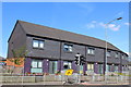
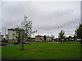
Modern Flats, Bridge of Weir Road, Linwood
Image: © Leslie Barrie
Taken: 25 Aug 2013
0.04 miles
2
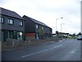
Bridge of Weir Road, Linwood
The colour of the bricks used for these houses give them a somewhat severe look
Image: © Elliott Simpson
Taken: 18 May 2012
0.06 miles
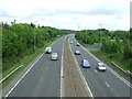
4
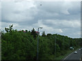
The A737 road at Linwood
The aircraft has just taken off from Glasgow Airport. Viewed from the cycle path bridge.
Image: © Thomas Nugent
Taken: 14 Jun 2013
0.11 miles
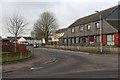
5
Linwood
In the late 18th century Linwood was a small village engaged in cotton milling, however in the
1960's Rootes Car Factory opened nearby and Linwood grew rapidly to house the 1000's of workers employed.
Image: © Chris Court
Taken: 15 Sep 2005
0.12 miles
6
The A737 road at Linwood
Looking towards Glasgow from the cycle path bridge.
Image: © Thomas Nugent
Taken: 14 Jun 2013
0.13 miles
7
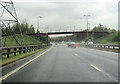
A737 north of Johnstone
Adjacent to the sewage works, the pylons cross the road here
Image: © John Firth
Taken: 10 May 2012
0.14 miles
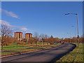
9
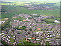
Housing at Linwood
An aerial view looking northwest just after leaving Glasgow on RWY 23. The white building at lower centre is Woodlands Primary School.
Image: © M J Richardson
Taken: 3 Jun 2015
0.15 miles
10
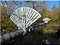
Pipe bridge over the Black Cart Water
For context, see Image, a view from a different angle.
Image: © Lairich Rig
Taken: 24 Oct 2019
0.19 miles