IMAGES TAKEN NEAR TO
Bridge Of Weir Road, PAISLEY, PA3 3ER
Introduction
This page details the photographs taken nearby to Bridge Of Weir Road, PA3 3ER by members of the Geograph project.
The Geograph project started in 2005 with the aim of publishing, organising and preserving representative images for every square kilometre of Great Britain, Ireland and the Isle of Man.

There are currently over 7.5m images from over14,400 individuals and you can help contribute to the project by visiting https://www.geograph.org.uk
Image Map
Images are licensed for reuse under creativecommons.org/licenses/by-sa/2.0
Notes
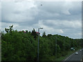
- Clicking on the map will re-center to the selected point.
- The higher the marker number, the further away the image location is from the centre of the postcode.
Image Listing (17 Images Found)
Images are licensed for reuse under creativecommons.org/licenses/by-sa/2.0
Image
Details
Distance
1
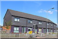
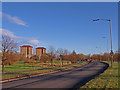
Modern Flats, Bridge of Weir Road, Linwood
Image: © Leslie Barrie
Taken: 25 Aug 2013
0.10 miles
2
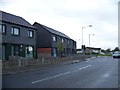
Bridge of Weir Road, Linwood
The colour of the bricks used for these houses give them a somewhat severe look
Image: © Elliott Simpson
Taken: 18 May 2012
0.10 miles
3
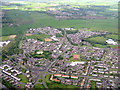
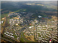
Housing at Linwood
An aerial view looking northwest just after leaving Glasgow on RWY 23. The white building at lower centre is Woodlands Primary School.
Image: © M J Richardson
Taken: 3 Jun 2015
0.10 miles
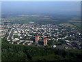
6
Linwood from the air
Looking over the A761 Bridge of Weir Road to Clippens.
Image: © Thomas Nugent
Taken: 20 Mar 2016
0.15 miles
7
Linwood from the air
Viewed from a flight from Luton on final approach to Glasgow from the southwest.
Image: © Thomas Nugent
Taken: 4 Sep 2010
0.15 miles
8
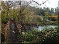
The Riverside Walk
It is signposted as such from a nearby path junction. The nearer watercourse, the one flowing under the bridge, is an old mill lade. As the map shows, the Black Cart Water runs close to the lade here; a bend in that river can be seen in the right background, though obscured a little by the vegetation. It is better seen from nearby: Image
See https://canmore.org.uk/site/272480 at Canmore for more on the mill lade.
Image: © Lairich Rig
Taken: 24 Oct 2019
0.19 miles
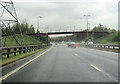
9
The A737 road at Linwood
The aircraft has just taken off from Glasgow Airport. Viewed from the cycle path bridge.
Image: © Thomas Nugent
Taken: 14 Jun 2013
0.19 miles
10
A737 north of Johnstone
Adjacent to the sewage works, the pylons cross the road here
Image: © John Firth
Taken: 10 May 2012
0.19 miles