IMAGES TAKEN NEAR TO
Underwood Road, PAISLEY, PA3 1TH
Introduction
This page details the photographs taken nearby to Underwood Road, PA3 1TH by members of the Geograph project.
The Geograph project started in 2005 with the aim of publishing, organising and preserving representative images for every square kilometre of Great Britain, Ireland and the Isle of Man.

There are currently over 7.5m images from over14,400 individuals and you can help contribute to the project by visiting https://www.geograph.org.uk
Image Map
Images are licensed for reuse under creativecommons.org/licenses/by-sa/2.0
Notes
- Clicking on the map will re-center to the selected point.
- The higher the marker number, the further away the image location is from the centre of the postcode.
Image Listing (173 Images Found)
Images are licensed for reuse under creativecommons.org/licenses/by-sa/2.0
Image
Details
Distance
1
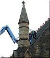
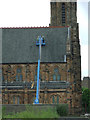
St James Church
A man at work on the roof of the Category B Listed building http://data.historic-scotland.gov.uk/pls/htmldb/f?p=2200:15:0::::BUILDING:39125 on Underwood Road.
Image: © Thomas Nugent
Taken: 14 Jun 2013
0.03 miles
2
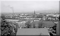
St James' Church of Scotland, Underwood Road, Paisley
Looking over the north of Paisley from the Coats Observatory.
Image: © Richard Sutcliffe
Taken: Unknown
0.03 miles
3
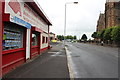
Underwood Road, Paisley
From the junction with Kerr Street.
Image: © Billy McCrorie
Taken: 21 Aug 2013
0.03 miles
4
St James Church
The west side of the Category B Listed building http://data.historic-scotland.gov.uk/pls/htmldb/f?p=2200:15:0::::BUILDING:39125 on Underwood Road building is now exposed following demolition of the former Scottish Milk Marketing Board buildings.
The Glasgow to Gourock & Wemyss Bay railway line is visible too.
Image: © Thomas Nugent
Taken: 14 Jun 2013
0.03 miles
5
St James Church
The west side of the Category B Listed building http://data.historic-scotland.gov.uk/pls/htmldb/f?p=2200:15:0::::BUILDING:39125 on Underwood Road building is now exposed following demolition of the former Scottish Milk Marketing Board buildings.
The Glasgow to Gourock & Wemyss Bay railway line is visible too.
Image: © Thomas Nugent
Taken: 14 Jun 2013
0.03 miles
6
St James Church
The west side of the Category B Listed building http://data.historic-scotland.gov.uk/pls/htmldb/f?p=2200:15:0::::BUILDING:39125 on Underwood Road building is now exposed following demolition of the former Scottish Milk Marketing Board buildings.
Image: © Thomas Nugent
Taken: 14 Jun 2013
0.03 miles
7
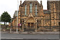
St James' Church, Paisley
On Underwood Road.
Image: © Billy McCrorie
Taken: 21 Aug 2013
0.03 miles
8
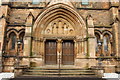
St James' Church, Paisley
On Underwood Road.
Image: © Billy McCrorie
Taken: 21 Aug 2013
0.03 miles
9
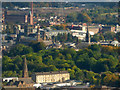
Paisley from the air
St James Church of Scotland on Underwood Road and Kerr Street are in the foreground. The wooded north slope of Oakshaw Hill dominates the centre, with Paisley Town Hall, Paisley Abbey, Mile End mill and the Embroidery Mill all visible beyond. Three of the churches on Oakshaw Hill can also be seen.
Image: © Thomas Nugent
Taken: 25 Sep 2017
0.04 miles
10
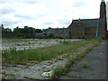
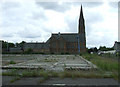
Site of Scottish Milk Marketing Board HQ
Now a brownfield site on Underwood Road.
See the same scene in 2011 Image
Image: © Thomas Nugent
Taken: 14 Jun 2013
0.04 miles