IMAGES TAKEN NEAR TO
Blackstoun Road, PAISLEY, PA3 1NT
Introduction
This page details the photographs taken nearby to Blackstoun Road, PA3 1NT by members of the Geograph project.
The Geograph project started in 2005 with the aim of publishing, organising and preserving representative images for every square kilometre of Great Britain, Ireland and the Isle of Man.

There are currently over 7.5m images from over14,400 individuals and you can help contribute to the project by visiting https://www.geograph.org.uk
Image Map
Images are licensed for reuse under creativecommons.org/licenses/by-sa/2.0
Notes
- Clicking on the map will re-center to the selected point.
- The higher the marker number, the further away the image location is from the centre of the postcode.
Image Listing (63 Images Found)
Images are licensed for reuse under creativecommons.org/licenses/by-sa/2.0
Image
Details
Distance
1
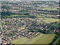
Ferguslie Park from the air
With south Paisley in the distance.
Image: © Thomas Nugent
Taken: 19 Jul 2015
0.00 miles
2
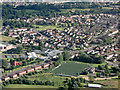
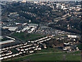
Ferguslie Park from the air
Sports, shopping and community facilities around the roundabout at Blackstoun Road and Ferguslie Park Avenue.
Image: © Thomas Nugent
Taken: 19 Jul 2015
0.00 miles
3
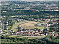
Ferguslie Park from the air
The old grey tenements have been demolished and the sites returned to grass or new, low density housing developments.
Image: © Thomas Nugent
Taken: 19 Jul 2015
0.00 miles
4
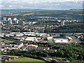
Ferguslie Park from the air
With south Paisley spread out beyond. St Mirren Park stadium is on the right, behind the JD Sports air tent.
Image: © Thomas Nugent
Taken: 19 Jul 2015
0.00 miles
5
Paisley from the air
Ferguslie Park is in the foreground where part of St Mirren Park football stadium is visible. Paisley gas works, Gilmour Street railway station (top left) and the town centre can also be seen.
Image: © Thomas Nugent
Taken: 18 Mar 2015
0.00 miles
6
The Tannahill Centre
Named after Paisley poet and weaver Robert Tannahill who died in 1810.
The centre houses a range of community services, including social and medical.
Image: © Richard Dorrell
Taken: 2 Apr 2019
0.03 miles
7

Ferguslie Park from the air
The once notorious housing scheme is long gone, replaced by modern housing, schools and public buildings. Glencoats Primary School is prominent, with St Fergus Primary School immediately beyond. Less prominent in the foreground (red brick building with dark grey roof) is Mirren Park School, which is an independent school.
Glencoats web site: https://blogs.glowscotland.org.uk/re/glencoatsprimary/ .
St Fergus web site: https://blogs.glowscotland.org.uk/re/stfergus/ .
Mirren Park web site: https://www.mirrenpark.org/ .
Image: © Thomas Nugent
Taken: 15 Jul 2019
0.04 miles
8
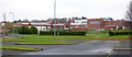
Glencoats Primary School
Viewed from Darkwood Crescent.
Image: © Thomas Nugent
Taken: 20 Nov 2016
0.05 miles
9

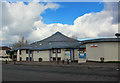
The Tannahill Centre
Viewed across the Ferguslie Avenue/Blackstoun Road roundabout. Named after the poet Robert Tannahill, a weaver from the town of Paisley, the Centre offers a range business and community space aiming to meet the needs of the local community.
Image: © Richard Dorrell
Taken: 2 Apr 2019
0.05 miles
10
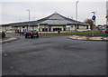
The Tannahill Centre
The Tannahill Centre is a 35,000 square feet facility in the heart of Ferguslie Park. It contains facilities such as a library, doctors surgery, café, chemist, nursery, learning centre, community hall and housing association office. Built in 1995 during the regeneration of Ferguslie Park.
Probably named after local poet Robert Tannahill who died in 1810 http://www.roberttannahillfederation.com/1.html .
Image: © Thomas Nugent
Taken: 20 Nov 2016
0.05 miles