IMAGES TAKEN NEAR TO
Manse Brae, LOCHGILPHEAD, PA31 8RD
Introduction
This page details the photographs taken nearby to Manse Brae, PA31 8RD by members of the Geograph project.
The Geograph project started in 2005 with the aim of publishing, organising and preserving representative images for every square kilometre of Great Britain, Ireland and the Isle of Man.

There are currently over 7.5m images from over14,400 individuals and you can help contribute to the project by visiting https://www.geograph.org.uk
Image Map
Images are licensed for reuse under creativecommons.org/licenses/by-sa/2.0
Notes
- Clicking on the map will re-center to the selected point.
- The higher the marker number, the further away the image location is from the centre of the postcode.
Image Listing (55 Images Found)
Images are licensed for reuse under creativecommons.org/licenses/by-sa/2.0
Image
Details
Distance
3
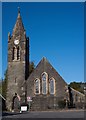
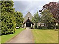
Lochgilphead Parish Church
Church of Scotland.
Image: © The Carlisle Kid
Taken: 12 Oct 2013
0.04 miles
4
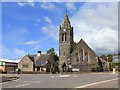
Lochgilphead Parish Church
The Church of Scotland parish church at the top of Argyll Street.
Image: © David P Howard
Taken: 22 Jul 2011
0.04 miles
5
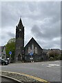
St. Margaret's RC Church
RC Diocese Of Argyll And The Isles, St. Margaret's church at the top of Argyll Street.
Image: © David P Howard
Taken: 22 Jul 2011
0.05 miles
7
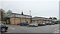
Co-op Supermarket, Oban Road, Lochgilphead
All under one roof.
Perhaps the reason for so few food shops in the town centre.
Image: © Bob Embleton
Taken: 13 Aug 2011
0.06 miles
8

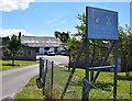
Argyll Tyres, Lochgilphead
Dutch barn style garage
Image: © Richard Webb
Taken: 20 Oct 2023
0.08 miles
9
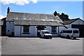
Drill Hall, Manse Brae
A drill hall is marked on the 2nd edition OS 1:2500 map (surveyed 1898). In 1914 it was the base for "E" Company, Argyll & Sutherland Highlanders. The hall survives within a Territorial Army Centre and is a slated stone-built hall with an aisle with porch facing the road.
Information from HS/RCAHMS World War One Audit Project (GJB) 19 September 2013.
Image: © Patrick Mackie
Taken: 10 Jul 2014
0.08 miles
10
Drill Hall, Manse Brae
A drill hall is marked on the 2nd edition OS 1:2500 map (surveyed 1898). In 1914 it was the base for "E" Company, Argyll & Sutherland Highlanders. The hall survives within a Territorial Army Centre and is a slated stone-built hall with an aisle with porch facing the road.
Information from HS/RCAHMS World War One Audit Project (GJB) 19 September 2013.
Image: © Patrick Mackie
Taken: 10 Jul 2014
0.08 miles