IMAGES TAKEN NEAR TO
Oakwood Avenue, PAISLEY, PA2 9NG
Introduction
This page details the photographs taken nearby to Oakwood Avenue, PA2 9NG by members of the Geograph project.
The Geograph project started in 2005 with the aim of publishing, organising and preserving representative images for every square kilometre of Great Britain, Ireland and the Isle of Man.

There are currently over 7.5m images from over14,400 individuals and you can help contribute to the project by visiting https://www.geograph.org.uk
Image Map
Images are licensed for reuse under creativecommons.org/licenses/by-sa/2.0
Notes
- Clicking on the map will re-center to the selected point.
- The higher the marker number, the further away the image location is from the centre of the postcode.
Image Listing (16 Images Found)
Images are licensed for reuse under creativecommons.org/licenses/by-sa/2.0
Image
Details
Distance
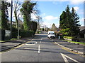
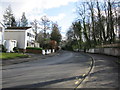
2
Corsebar Road
From the junction with Moredun Drive.
Image: © Billy McCrorie
Taken: 21 Feb 2013
0.12 miles
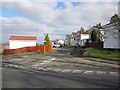
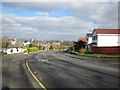
3
Moredun Road becomes Corsebar Road
All part of the B775.
Image: © Stephen Sweeney
Taken: 29 Oct 2009
0.13 miles
4
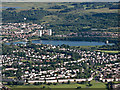
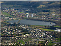
Lounsdale and Stanely Castle Reservoir from the air
Morar Drive is in the foreground. Stanely Castle can be seen to the right within the reservoir.
Image: © Thomas Nugent
Taken: 19 Jul 2015
0.14 miles
5
Stanely Reservoir from the air
In the south side of Paisley, at the foot of the Glennifer Braes.
Image: © Thomas Nugent
Taken: 17 Apr 2016
0.14 miles
6
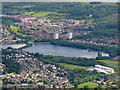
Brediland and Stanely Reservoir from the air
In the southern suburbs of Paisley.
Image: © Thomas Nugent
Taken: 5 Jun 2017
0.14 miles