IMAGES TAKEN NEAR TO
Green Road, PAISLEY, PA2 9AJ
Introduction
This page details the photographs taken nearby to Green Road, PA2 9AJ by members of the Geograph project.
The Geograph project started in 2005 with the aim of publishing, organising and preserving representative images for every square kilometre of Great Britain, Ireland and the Isle of Man.

There are currently over 7.5m images from over14,400 individuals and you can help contribute to the project by visiting https://www.geograph.org.uk
Image Map
Images are licensed for reuse under creativecommons.org/licenses/by-sa/2.0
Notes
- Clicking on the map will re-center to the selected point.
- The higher the marker number, the further away the image location is from the centre of the postcode.
Image Listing (15 Images Found)
Images are licensed for reuse under creativecommons.org/licenses/by-sa/2.0
Image
Details
Distance
1
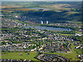
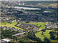
Paisley from the air
Morar Drive is in the foreground, with Stanely Reservoir and its castle dominating the background. Glenburn Reservoir can be seen on the hill.
Image: © Thomas Nugent
Taken: 15 May 2016
0.10 miles
2
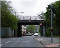
Old railway bridge
Carries the former Paisley Canal line over Fulbar Road. The line is now part of the National Cycle NetworkRoute 75.
Image: © Thomas Nugent
Taken: 26 Apr 2009
0.12 miles
3
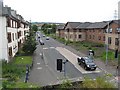
Fulbar Road
Fulbar Road seen from a bridge that carried the Paisley Canal railway over the road. The railway is now a cycle path between Paisley and Johnstone.
Image: © Richard Webb
Taken: 22 Jun 2009
0.12 miles
4
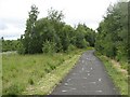
Paisley Canal Line
Now National Cycle Network route 7 and 75.
Image: © Richard Webb
Taken: 22 Jun 2009
0.16 miles
5
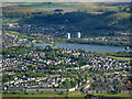
Paisley from the air
The BUPA Care Home on Fulbar Road is the H shaped building in the foreground. Fulbar Crescent and Peacock Drive are in the centre, Stanely Reservoir and castle are in the distance.
Image: © Thomas Nugent
Taken: 7 Aug 2017
0.17 miles
6

Aldi, Paisley
On Fulbar Road, between Millarston and Foxbar.
Image: © Stephen Sweeney
Taken: 3 Jan 2010
0.18 miles
7
Paisley from the air
Morar Drive is in the foreground, with Stanely Reservoir and its castle dominating the background. Glenburn Reservoir can be seen on the hill.
Image: © Thomas Nugent
Taken: 15 May 2016
0.21 miles
8
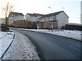
Entering Foxbar
From Fulbar Road into Dee Drive.
Image: © Stephen Sweeney
Taken: 3 Jan 2010
0.21 miles
9
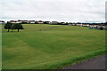
Recreation ground
A large open area, viewed here looking north from Morar Drive.
Image: © Richard Dorrell
Taken: 10 Aug 2021
0.21 miles
10
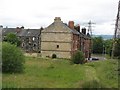
Tenements, Millarston
A suggestion that some have been removed from here. Seen from the Paisley Canal railway trackbed.
Image: © Richard Webb
Taken: 22 Jun 2009
0.21 miles